Ducey geodata
Ducey (Normandy) is a populated place; located in France in Europe/Paris (GMT+2) time zone. With population of 2,272 people, there are 4238 cities with bigger population in this country. Compared to other cities in France, 71.3% of cities are located further ↓South; 90.7% of cities are located further →East and 91.2% of cities have higher elevation than Ducey. Note1
Administrative division(s):
- Level 1: Normandy
- Level 2: Manche
- Level 3: Avranches
- Level 4: Ducey-Les Chéris


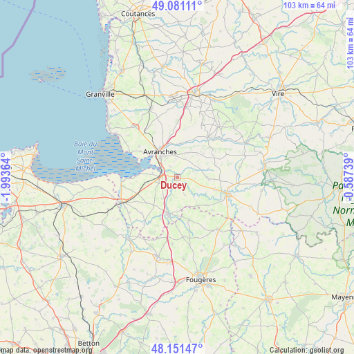
Ducey GPS coordinates[2]
48° 37' 6.348" North, 1° 17' 25.872" West
| Map corner | latitude | longitude |
|---|---|---|
| Upper-left | 49.08111°, | -1.99364° |
| Center: | 48.61843°, | -1.29052° |
| Lower-right: | 48.15147°, | -0.58739° |
| Map W x H: | 103.4×103.4 km | = 64.2×64.2mi |
| max Lat: | 51.07786° ⇑28.7% North |
| Ducey: | 48.61843° |
| min Lat: | ⇓71.3% South 41.3874° |
| min Long | Ducey | max Long |
| -5.08615° | -1.29052° | 9.52242° |
| W 9.3%⇐ | ⇒90.7% E |
Elevation
Elevation of Ducey is 27 m = 89 ft, and this is 166.7 m = 547 ft below average elevation for this country.
| Max E: |
2333 m = 7654 ft | 91.2% |
| Avg. | 193.7 m = 635 ft | |
| Ducey | 27 m = 89 ft | |
Min E: |
-1 m = -3 ft | 8.8% |
See also: France elevation on elevation.city.
Geographical zone
Ducey is located in North temperate zone (between Tropic of Cancer and the Arctic Circle). Distance of this North polar circle is 1995.3 km =1239.8 mi to North.| Distance of | km | miles | from Ducey |
|---|---|---|---|
| North Pole | 4601.2 | 2859.1 | to North |
| Arctic Circle | 1995.3 | 1239.8 | to North |
| Tropic Cancer | 2799.9 | 1739.8 | to South |
| Equator | 5405.9 | 3359.1 | to South |


Nearby cities:
15 places around Ducey: (largest is in red/bold)
• Avranches
8.8 km =5.5 mi,  326°
326°
• Isigny-le-Buat
8.9 km =5.5 mi,  90°
90°
• Le Grand-Celland
10.4 km =6.5 mi,  48°
48°
• Le Val-Saint-Père
7.9 km =4.9 mi,  307°
307°
• Marcey-les-Grèves
11.4 km =7.1 mi,  319°
319°
• Poilley
1.4 km =0.9 mi,  267°
267°
• Saint-Aubin-de-Terregatte
4.8 km =3 mi,  188°
188°
• Saint-James
11.1 km =6.9 mi, 193°
• Saint-Laurent-de-Terregatte
5.7 km =3.5 mi,  156°
156°
• Saint-Loup
5.5 km =3.4 mi,  356°
356°
• Saint-Martin-des-Champs
6.4 km =4 mi, 330°
• Saint-Quentin-sur-le-Homme
3.8 km =2.4 mi, 327°
• Saint-Senier-sous-Avranches
7.9 km =4.9 mi,  337°
337°
• Tirepied
10.4 km =6.5 mi,  10°
10°
• Vains
11.4 km =7.1 mi, 307°
Sources, notices
• [Note1] Compared only with cities in France existing in our database
• [Src1] Map data: © OpenStreetMap contributors (CC-BY-SA)
• [Src2] Other city data from geonames.org with taken over terms of usage.
• [Src3] Geographical zone / Annual Mean Temperature by Robert A. Rohde @ Wikipedia
