Avranches geodata
Avranches (Normandy) is a seat of a third-order administrative division; located in France in Europe/Paris (GMT+2) time zone. With population of 9,295 people, there are 1032 cities with bigger population in this country. Compared to other cities in France, 72.9% of cities are located further ↓South; 91.2% of cities are located further →East and 68.3% of cities have higher elevation than Avranches. Note1


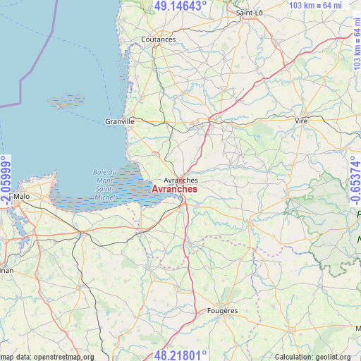
Avranches GPS coordinates[2]
48° 41' 3.696" North, 1° 21' 24.696" West
| Map corner | latitude | longitude |
|---|---|---|
| Upper-left | 49.14643°, | -2.05999° |
| Center: | 48.68436°, | -1.35686° |
| Lower-right: | 48.21801°, | -0.65374° |
| Map W x H: | 103.2×103.2 km | = 64.1×64.1mi |
| max Lat: | 51.07786° ⇑27.1% North |
| Avranches: | 48.68436° |
| min Lat: | ⇓72.9% South 41.3874° |
| min Long | Avranches | max Long |
| -5.08615° | -1.35686° | 9.52242° |
| W 8.8%⇐ | ⇒91.2% E |
Elevation
Elevation of Avranches is 82 m = 269 ft, and this is 111.7 m = 366 ft below average elevation for this country.
| Max E: |
2333 m = 7654 ft | 68.3% |
| Avg. | 193.7 m = 635 ft | |
| Avranches | 82 m = 269 ft | |
Min E: |
-1 m = -3 ft | 31.7% |
See also: France elevation on elevation.city.
Geographical zone
Avranches is located in North temperate zone (between Tropic of Cancer and the Arctic Circle). Distance of this North polar circle is 1988 km =1235.3 mi to North.| Distance of | km | miles | from Avranches |
|---|---|---|---|
| North Pole | 4593.9 | 2854.5 | to North |
| Arctic Circle | 1988 | 1235.3 | to North |
| Tropic Cancer | 2807.3 | 1744.4 | to South |
| Equator | 5413.2 | 3363.6 | to South |


Nearby cities:
15 places around Avranches: (largest is in red/bold)
• Bacilly
6.4 km =4 mi,  286°
286°
• Dragey-Ronthon
11.1 km =6.9 mi, 288°
• Ducey
8.8 km =5.5 mi,  146°
146°
• Le Grand-Celland
12.6 km =7.8 mi,  91°
91°
• Le Val-Saint-Père
2.9 km =1.8 mi,  209°
209°
• Lolif
6 km =3.7 mi,  334°
334°
• Marcey-les-Grèves
2.9 km =1.8 mi,  298°
298°
• Poilley
8.1 km =5 mi,  155°
155°
• Saint-Loup
4.9 km =3 mi,  112°
112°
• Saint-Martin-des-Champs
2.4 km =1.5 mi,  136°
136°
• Saint-Quentin-sur-le-Homme
5 km =3.1 mi, 145°
• Saint-Senier-sous-Avranches
1.9 km =1.2 mi, 91°
• Sartilly
10.5 km =6.5 mi,  315°
315°
• Tirepied
7.4 km =4.6 mi,  67°
67°
• Vains
4.2 km =2.6 mi,  264°
264°
Sources, notices
• [Note1] Compared only with cities in France existing in our database
• [Src1] Map data: © OpenStreetMap contributors (CC-BY-SA)
• [Src2] Other city data from geonames.org with taken over terms of usage.
• [Src3] Geographical zone / Annual Mean Temperature by Robert A. Rohde @ Wikipedia
