Le Val-Saint-Père geodata
Le Val-Saint-Père (Normandy) is a populated place; located in France in Europe/Paris (GMT+2) time zone. With population of 1,656 people, there are 5645 cities with bigger population in this country. Compared to other cities in France, 72.3% of cities are located further ↓South; 91.3% of cities are located further →East and 96.3% of cities have higher elevation than Le Val-Saint-Père. Note1
Administrative division(s):
- Level 1: Normandy
- Level 2: Manche
- Level 3: Avranches
- Level 4: Le Val-Saint-Père


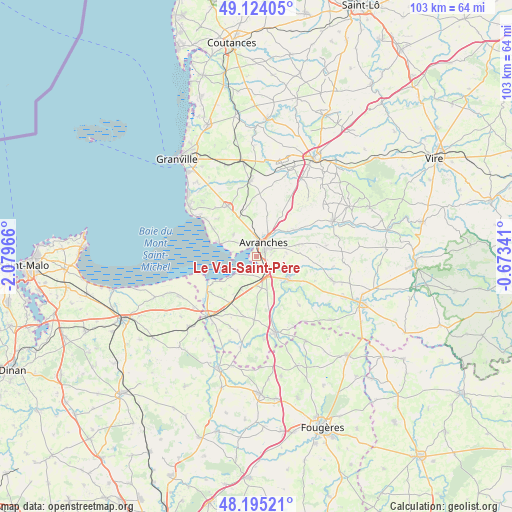
Le Val-Saint-Père GPS coordinates[2]
48° 39' 42.372" North, 1° 22' 35.508" West
| Map corner | latitude | longitude |
|---|---|---|
| Upper-left | 49.12405°, | -2.07966° |
| Center: | 48.66177°, | -1.37653° |
| Lower-right: | 48.19521°, | -0.67341° |
| Map W x H: | 103.3×103.3 km | = 64.2×64.2mi |
| max Lat: | 51.07786° ⇑27.7% North |
| Le Val-Saint-Père: | 48.66177° |
| min Lat: | ⇓72.3% South 41.3874° |
| min Long | Le Val-Saint-P� | max Long |
| -5.08615° | -1.37653° | 9.52242° |
| W 8.7%⇐ | ⇒91.3% E |
Elevation
Elevation of Le Val-Saint-Père is 13 m = 43 ft, and this is 180.7 m = 593 ft below average elevation for this country.
| Max E: |
2333 m = 7654 ft | 96.3% |
| Avg. | 193.7 m = 635 ft | |
| Le Val-Saint-Père | 13 m = 43 ft | |
Min E: |
-1 m = -3 ft | 3.7% |
See also: France elevation on elevation.city.
Geographical zone
Le Val-Saint-Père is located in North temperate zone (between Tropic of Cancer and the Arctic Circle). Distance of this North polar circle is 1990.5 km =1236.8 mi to North.| Distance of | km | miles | from Le Val-Saint-Père |
|---|---|---|---|
| North Pole | 4596.4 | 2856.1 | to North |
| Arctic Circle | 1990.5 | 1236.8 | to North |
| Tropic Cancer | 2804.8 | 1742.8 | to South |
| Equator | 5410.7 | 3362.1 | to South |


Nearby cities:
15 places around Le Val-Saint-Père: (largest is in red/bold)
• Avranches
2.9 km =1.8 mi,  29°
29°
• Bacilly
6.4 km =4 mi,  312°
312°
• Dragey-Ronthon
10.9 km =6.8 mi,  303°
303°
• Ducey
7.9 km =4.9 mi,  127°
127°
• Lolif
8 km =5 mi,  351°
351°
• Marcey-les-Grèves
4 km =2.5 mi,  344°
344°
• Poilley
6.9 km =4.3 mi, 134°
• Saint-Aubin-de-Terregatte
11.1 km =6.9 mi,  149°
149°
• Saint-Loup
6 km =3.7 mi,  83°
83°
• Saint-Martin-des-Champs
3.2 km =2 mi, 76°
• Saint-Quentin-sur-le-Homme
4.6 km =2.9 mi,  110°
110°
• Saint-Senier-sous-Avranches
4.1 km =2.5 mi,  53°
53°
• Sartilly
11.7 km =7.3 mi,  329°
329°
• Tirepied
9.8 km =6.1 mi,  56°
56°
• Vains
3.4 km =2.1 mi, 307°
Sources, notices
• [Note1] Compared only with cities in France existing in our database
• [Src1] Map data: © OpenStreetMap contributors (CC-BY-SA)
• [Src2] Other city data from geonames.org with taken over terms of usage.
• [Src3] Geographical zone / Annual Mean Temperature by Robert A. Rohde @ Wikipedia
