Dozulé geodata
Dozulé (Normandy) is a populated place; located in France in Europe/Paris (GMT+2) time zone. With population of 1,689 people, there are 5548 cities with bigger population in this country. Compared to other cities in France, 84.8% of cities are located further ↓South; 78.4% of cities are located further →East and 90.7% of cities have higher elevation than Dozulé. Note1
Administrative division(s):
- Level 1: Normandy
- Level 2: Calvados
- Level 3: Arrondissement de Lisieux
- Level 4: Dozulé


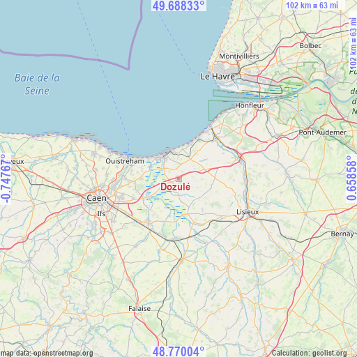
Dozulé GPS coordinates[2]
49° 13' 52.752" North, 0° 2' 40.344" West
| Map corner | latitude | longitude |
|---|---|---|
| Upper-left | 49.68833°, | -0.74767° |
| Center: | 49.23132°, | -0.04454° |
| Lower-right: | 48.77004°, | 0.65858° |
| Map W x H: | 102.1×102.1 km | = 63.4×63.4mi |
| max Lat: | 51.07786° ⇑15.2% North |
| Dozulé: | 49.23132° |
| min Lat: | ⇓84.8% South 41.3874° |
| min Long | Dozulé | max Long |
| -5.08615° | -0.04454° | 9.52242° |
| W 21.6%⇐ | ⇒78.4% E |
Elevation
Elevation of Dozulé is 28 m = 92 ft, and this is 165.7 m = 544 ft below average elevation for this country.
| Max E: |
2333 m = 7654 ft | 90.7% |
| Avg. | 193.7 m = 635 ft | |
| Dozulé | 28 m = 92 ft | |
Min E: |
-1 m = -3 ft | 9.3% |
See also: France elevation on elevation.city.
Geographical zone
Dozulé is located in North temperate zone (between Tropic of Cancer and the Arctic Circle). Distance of this North polar circle is 1927.2 km =1197.5 mi to North.| Distance of | km | miles | from Dozulé |
|---|---|---|---|
| North Pole | 4533.1 | 2816.7 | to North |
| Arctic Circle | 1927.2 | 1197.5 | to North |
| Tropic Cancer | 2868.1 | 1782.2 | to South |
| Equator | 5474 | 3401.4 | to South |


Nearby cities:
15 places around Dozulé: (largest is in red/bold)
• Bavent
10.3 km =6.4 mi,  269°
269°
• Beaumont-en-Auge
12.4 km =7.7 mi,  65°
65°
• Blonville-sur-Mer
12.9 km =8 mi,  23°
23°
• Bonnebosq
9.4 km =5.8 mi,  109°
109°
• Cabourg
8.3 km =5.2 mi,  323°
323°
• Cambremer
11.1 km =6.9 mi,  142°
142°
• Dives-sur-Mer
7 km =4.3 mi, 323°
• Gonneville-sur-Mer
5.4 km =3.4 mi,  2°
2°
• Houlgate
8 km =5 mi,  340°
340°
• Merville-Franceville-Plage
11.9 km =7.4 mi,  292°
292°
• Méry-Corbon
11 km =6.8 mi,  194°
194°
• Tourgeville
13 km =8.1 mi,  39°
39°
• Troarn
11.6 km =7.2 mi,  239°
239°
• Varaville
8.6 km =5.3 mi, 286°
• Villers-sur-Mer
10.7 km =6.6 mi, 17°
Sources, notices
• [Note1] Compared only with cities in France existing in our database
• [Src1] Map data: © OpenStreetMap contributors (CC-BY-SA)
• [Src2] Other city data from geonames.org with taken over terms of usage.
• [Src3] Geographical zone / Annual Mean Temperature by Robert A. Rohde @ Wikipedia
