Bonnebosq geodata
Bonnebosq (Normandy) is a populated place; located in France in Europe/Paris (GMT+2) time zone. With population of 690 people, there are 11939 cities with bigger population in this country. Compared to other cities in France, 84.3% of cities are located further ↓South; 77.4% of cities are located further →East and 71.9% of cities have higher elevation than Bonnebosq. Note1
Administrative division(s):
- Level 1: Normandy
- Level 2: Calvados
- Level 3: Arrondissement de Lisieux
- Level 4: Bonnebosq


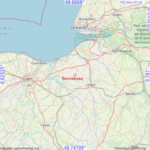
Bonnebosq GPS coordinates[2]
49° 12' 12.708" North, 0° 4' 40.368" East
| Map corner | latitude | longitude |
|---|---|---|
| Upper-left | 49.6608°, | -0.62525° |
| Center: | 49.20353°, | 0.07788° |
| Lower-right: | 48.74199°, | 0.781° |
| Map W x H: | 102.2×102.2 km | = 63.5×63.5mi |
| max Lat: | 51.07786° ⇑15.7% North |
| Bonnebosq: | 49.20353° |
| min Lat: | ⇓84.3% South 41.3874° |
| min Long | Bonnebosq | max Long |
| -5.08615° | 0.07788° | 9.52242° |
| W 22.6%⇐ | ⇒77.4% E |
Elevation
Elevation of Bonnebosq is 74 m = 243 ft, and this is 119.7 m = 393 ft below average elevation for this country.
| Max E: |
2333 m = 7654 ft | 71.9% |
| Avg. | 193.7 m = 635 ft | |
| Bonnebosq | 74 m = 243 ft | |
Min E: |
-1 m = -3 ft | 28.1% |
See also: France elevation on elevation.city.
Geographical zone
Bonnebosq is located in North temperate zone (between Tropic of Cancer and the Arctic Circle). Distance of this North polar circle is 1930.3 km =1199.4 mi to North.| Distance of | km | miles | from Bonnebosq |
|---|---|---|---|
| North Pole | 4536.1 | 2818.6 | to North |
| Arctic Circle | 1930.3 | 1199.4 | to North |
| Tropic Cancer | 2865 | 1780.2 | to South |
| Equator | 5470.9 | 3399.5 | to South |


Nearby cities:
15 places around Bonnebosq: (largest is in red/bold)
• Beaumont-en-Auge
8.6 km =5.3 mi,  15°
15°
• Cambremer
6.1 km =3.8 mi,  200°
200°
• Coquainvilliers
9.6 km =6 mi,  93°
93°
• Crevecoeur-en-Auge
10.6 km =6.6 mi, 204°
• Dozulé
9.4 km =5.8 mi,  289°
289°
• Gonneville-sur-Mer
12.1 km =7.5 mi,  314°
314°
• Le Breuil-en-Auge
11 km =6.8 mi,  75°
75°
• Lisieux
12.7 km =7.9 mi,  119°
119°
• Manerbe
7.3 km =4.5 mi,  106°
106°
• Méry-Corbon
13.9 km =8.6 mi,  237°
237°
• Ouilly-le-Vicomte
10.8 km =6.7 mi,  102°
102°
• Pont-l’Évêque
12.6 km =7.8 mi,  40°
40°
• Saint-Désir
12.1 km =7.5 mi,  125°
125°
• Saint-Hymer
8.9 km =5.5 mi,  51°
51°
• Tourgeville
13.1 km =8.1 mi,  357°
357°
Sources, notices
• [Note1] Compared only with cities in France existing in our database
• [Src1] Map data: © OpenStreetMap contributors (CC-BY-SA)
• [Src2] Other city data from geonames.org with taken over terms of usage.
• [Src3] Geographical zone / Annual Mean Temperature by Robert A. Rohde @ Wikipedia
