Méry-Corbon geodata
Méry-Corbon (Normandy) is a populated place; located in France in Europe/Paris (GMT+2) time zone. With population of 882 people, there are 9803 cities with bigger population in this country. Compared to other cities in France, 83% of cities are located further ↓South; 78.8% of cities are located further →East and 96% of cities have higher elevation than Méry-Corbon. Note1
Administrative division(s):
- Level 1: Normandy
- Level 2: Calvados
- Level 3: Arrondissement de Lisieux
- Level 4: Méry-Bissières-en-Auge


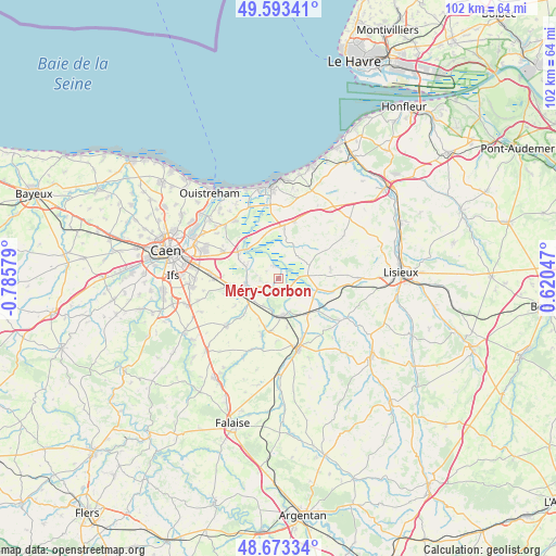
Méry-Corbon GPS coordinates[2]
49° 8' 7.836" North, 0° 4' 57.576" West
| Map corner | latitude | longitude |
|---|---|---|
| Upper-left | 49.59341°, | -0.78579° |
| Center: | 49.13551°, | -0.08266° |
| Lower-right: | 48.67334°, | 0.62047° |
| Map W x H: | 102.3×102.3 km | = 63.6×63.6mi |
| max Lat: | 51.07786° ⇑17% North |
| Méry-Corbon: | 49.13551° |
| min Lat: | ⇓83% South 41.3874° |
| min Long | Méry-Corbon | max Long |
| -5.08615° | -0.08266° | 9.52242° |
| W 21.2%⇐ | ⇒78.8% E |
Elevation
Elevation of Méry-Corbon is 14 m = 46 ft, and this is 179.7 m = 590 ft below average elevation for this country.
| Max E: |
2333 m = 7654 ft | 96% |
| Avg. | 193.7 m = 635 ft | |
| Méry-Corbon | 14 m = 46 ft | |
Min E: |
-1 m = -3 ft | 4% |
See also: France elevation on elevation.city.
Geographical zone
Méry-Corbon is located in North temperate zone (between Tropic of Cancer and the Arctic Circle). Distance of this North polar circle is 1937.8 km =1204.1 mi to North.| Distance of | km | miles | from Méry-Corbon |
|---|---|---|---|
| North Pole | 4543.7 | 2823.3 | to North |
| Arctic Circle | 1937.8 | 1204.1 | to North |
| Tropic Cancer | 2857.4 | 1775.5 | to South |
| Equator | 5463.4 | 3394.8 | to South |


Nearby cities:
15 places around Méry-Corbon: (largest is in red/bold)
• Airan
6.3 km =3.9 mi,  232°
232°
• Argences
6.2 km =3.9 mi,  260°
260°
• Bellengreville
9.3 km =5.8 mi, 262°
• Cagny
12.7 km =7.9 mi,  275°
275°
• Cambremer
9.6 km =6 mi,  79°
79°
• Canon
6.9 km =4.3 mi,  185°
185°
• Chicheboville
10.1 km =6.3 mi,  253°
253°
• Crevecoeur-en-Auge
7.5 km =4.7 mi,  106°
106°
• Dozulé
11 km =6.8 mi,  14°
14°
• Le Mesnil-Mauger
9.2 km =5.7 mi,  128°
128°
• Magny-la-Campagne
9.8 km =6.1 mi, 189°
• Moult
6.4 km =4 mi, 249°
• Sannerville
11.4 km =7.1 mi,  295°
295°
• Troarn
8.6 km =5.3 mi, 303°
• Vimont
8.6 km =5.3 mi, 260°
Sources, notices
• [Note1] Compared only with cities in France existing in our database
• [Src1] Map data: © OpenStreetMap contributors (CC-BY-SA)
• [Src2] Other city data from geonames.org with taken over terms of usage.
• [Src3] Geographical zone / Annual Mean Temperature by Robert A. Rohde @ Wikipedia
