Dourdan geodata
Dourdan (Île-de-France) is a populated place; located in France in Europe/Paris (GMT+2) time zone. With population of 10,261 people, there are 920 cities with bigger population in this country. Compared to other cities in France, 69% of cities are located further ↓South; 57% of cities are located further →East and 62.8% of cities have higher elevation than Dourdan. Note1
Administrative division(s):
- Level 1: Île-de-France
- Level 2: Département de l'Essonne
- Level 3: Arrondissement d'Étampes
- Level 4: Dourdan


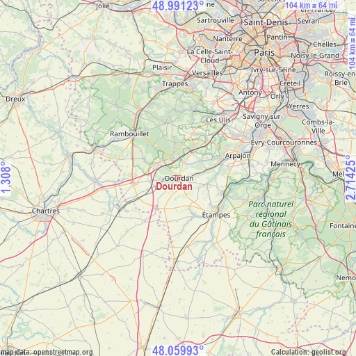
Dourdan GPS coordinates[2]
48° 31' 39.792" North, 2° 0' 40.068" East
| Map corner | latitude | longitude |
|---|---|---|
| Upper-left | 48.99123°, | 1.308° |
| Center: | 48.52772°, | 2.01113° |
| Lower-right: | 48.05993°, | 2.71425° |
| Map W x H: | 103.6×103.5 km | = 64.4×64.3mi |
| max Lat: | 51.07786° ⇑31% North |
| Dourdan: | 48.52772° |
| min Lat: | ⇓69% South 41.3874° |
| min Long | Dourdan | max Long |
| -5.08615° | 2.01113° | 9.52242° |
| W 43%⇐ | ⇒57% E |
Elevation
Elevation of Dourdan is 95 m = 312 ft, and this is 98.7 m = 324 ft below average elevation for this country.
| Max E: |
2333 m = 7654 ft | 62.8% |
| Avg. | 193.7 m = 635 ft | |
| Dourdan | 95 m = 312 ft | |
Min E: |
-1 m = -3 ft | 37.2% |
See also: France elevation on elevation.city.
Geographical zone
Dourdan is located in North temperate zone (between Tropic of Cancer and the Arctic Circle). Distance of this North polar circle is 2005.4 km =1246.1 mi to North.| Distance of | km | miles | from Dourdan |
|---|---|---|---|
| North Pole | 4611.3 | 2865.3 | to North |
| Arctic Circle | 2005.4 | 1246.1 | to North |
| Tropic Cancer | 2789.9 | 1733.6 | to South |
| Equator | 5395.8 | 3352.8 | to South |


Nearby cities:
15 places around Dourdan: (largest is in red/bold)
• Angervilliers
8.2 km =5.1 mi,  28°
28°
• Boissy-le-Sec
8 km =5 mi,  133°
133°
• Bonnelles
10.1 km =6.3 mi,  7°
7°
• Bouville
6.2 km =3.9 mi,  45°
45°
• Corbreuse
4.9 km =3 mi,  231°
231°
• Le Val-Saint-Germain
5.8 km =3.6 mi,  42°
42°
• Les Granges-le-Roi
2.9 km =1.8 mi,  167°
167°
• Ponthévrard
7.9 km =4.9 mi,  289°
289°
• Rochefort-en-Yvelines
6.6 km =4.1 mi,  344°
344°
• Roinville
2.3 km =1.4 mi,  80°
80°
• Saint-Arnoult-en-Yvelines
7.1 km =4.4 mi,  312°
312°
• Saint-Chéron
8.8 km =5.5 mi,  70°
70°
• Saint-Cyr-sous-Dourdan
4.6 km =2.9 mi,  20°
20°
• Saint-Maurice-Montcouronne
10.4 km =6.5 mi, 53°
• Villeconin
8.5 km =5.3 mi,  100°
100°
Sources, notices
• [Note1] Compared only with cities in France existing in our database
• [Src1] Map data: © OpenStreetMap contributors (CC-BY-SA)
• [Src2] Other city data from geonames.org with taken over terms of usage.
• [Src3] Geographical zone / Annual Mean Temperature by Robert A. Rohde @ Wikipedia
