Saint-Chéron geodata
Saint-Chéron (Île-de-France) is a populated place; located in France in Europe/Paris (GMT+2) time zone. With population of 4,690 people, there are 2106 cities with bigger population in this country. Compared to other cities in France, 69.7% of cities are located further ↓South; 55.5% of cities are located further →East and 60.4% of cities have higher elevation than Saint-Chéron. Note1
Administrative division(s):
- Level 1: Île-de-France
- Level 2: Département de l'Essonne
- Level 3: Arrondissement d'Étampes
- Level 4: Saint-Chéron


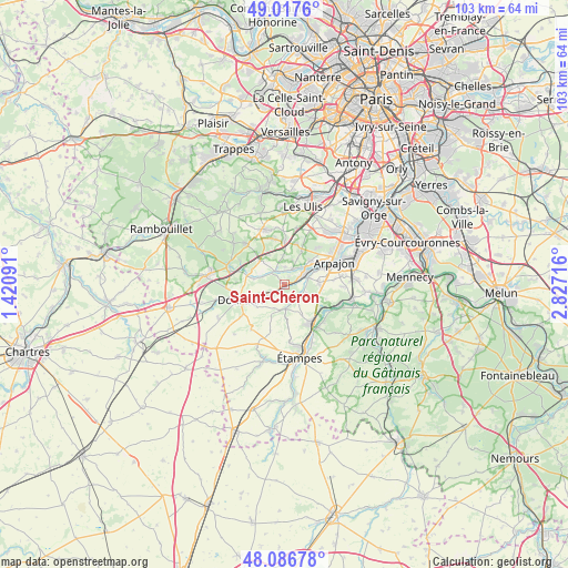
Saint-Chéron GPS coordinates[2]
48° 33' 15.588" North, 2° 7' 26.508" East
| Map corner | latitude | longitude |
|---|---|---|
| Upper-left | 49.0176°, | 1.42091° |
| Center: | 48.55433°, | 2.12403° |
| Lower-right: | 48.08678°, | 2.82716° |
| Map W x H: | 103.5×103.5 km | = 64.3×64.3mi |
| max Lat: | 51.07786° ⇑30.3% North |
| Saint-Chéron: | 48.55433° |
| min Lat: | ⇓69.7% South 41.3874° |
| min Long | Saint-Chéron | max Long |
| -5.08615° | 2.12403° | 9.52242° |
| W 44.5%⇐ | ⇒55.5% E |
Elevation
Elevation of Saint-Chéron is 101 m = 331 ft, and this is 92.7 m = 304 ft below average elevation for this country.
| Max E: |
2333 m = 7654 ft | 60.4% |
| Avg. | 193.7 m = 635 ft | |
| Saint-Chéron | 101 m = 331 ft | |
Min E: |
-1 m = -3 ft | 39.6% |
See also: France elevation on elevation.city.
Geographical zone
Saint-Chéron is located in North temperate zone (between Tropic of Cancer and the Arctic Circle). Distance of this North polar circle is 2002.4 km =1244.2 mi to North.| Distance of | km | miles | from Saint-Chéron |
|---|---|---|---|
| North Pole | 4608.3 | 2863.5 | to North |
| Arctic Circle | 2002.4 | 1244.2 | to North |
| Tropic Cancer | 2792.8 | 1735.4 | to South |
| Equator | 5398.7 | 3354.6 | to South |


Nearby cities:
15 places around Saint-Chéron: (largest is in red/bold)
• Angervilliers
6.1 km =3.8 mi,  314°
314°
• Boissy-sous-Saint-Yon
6.5 km =4 mi,  90°
90°
• Bouville
4.1 km =2.5 mi,  289°
289°
• Breuillet
4.1 km =2.5 mi,  63°
63°
• Briis-sous-Forges
7.7 km =4.8 mi,  358°
358°
• Bruyères-le-Châtel
6.2 km =3.9 mi,  51°
51°
• Courson-Monteloup
5.5 km =3.4 mi,  20°
20°
• Fontenay-lès-Briis
7.6 km =4.7 mi, 16°
• Le Val-Saint-Germain
4.6 km =2.9 mi, 286°
• Roinville
6.5 km =4 mi,  246°
246°
• Saint-Cyr-sous-Dourdan
6.8 km =4.2 mi,  281°
281°
• Saint-Maurice-Montcouronne
3.2 km =2 mi,  1°
1°
• Saint-Yon
4.9 km =3 mi, 85°
• Vaugrigneuse
5.4 km =3.4 mi, 358°
• Villeconin
4.5 km =2.8 mi,  178°
178°
Sources, notices
• [Note1] Compared only with cities in France existing in our database
• [Src1] Map data: © OpenStreetMap contributors (CC-BY-SA)
• [Src2] Other city data from geonames.org with taken over terms of usage.
• [Src3] Geographical zone / Annual Mean Temperature by Robert A. Rohde @ Wikipedia
