Angervilliers geodata
Angervilliers (Île-de-France) is a populated place; located in France in Europe/Paris (GMT+2) time zone. With population of 1,458 people, there are 6339 cities with bigger population in this country. Compared to other cities in France, 70.7% of cities are located further ↓South; 56.2% of cities are located further →East and 55.6% of cities have higher elevation than Angervilliers. Note1
Administrative division(s):
- Level 1: Île-de-France
- Level 2: Département de l'Essonne
- Level 3: Arrondissement de Palaiseau
- Level 4: Angervilliers


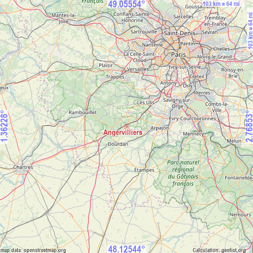
Angervilliers GPS coordinates[2]
48° 35' 33.468" North, 2° 3' 55.476" East
| Map corner | latitude | longitude |
|---|---|---|
| Upper-left | 49.05554°, | 1.36228° |
| Center: | 48.59263°, | 2.06541° |
| Lower-right: | 48.12544°, | 2.76853° |
| Map W x H: | 103.4×103.4 km | = 64.2×64.2mi |
| max Lat: | 51.07786° ⇑29.3% North |
| Angervilliers: | 48.59263° |
| min Lat: | ⇓70.7% South 41.3874° |
| min Long | Angervilliers | max Long |
| -5.08615° | 2.06541° | 9.52242° |
| W 43.8%⇐ | ⇒56.2% E |
Elevation
Elevation of Angervilliers is 115 m = 377 ft, and this is 78.7 m = 258 ft below average elevation for this country.
| Max E: |
2333 m = 7654 ft | 55.6% |
| Avg. | 193.7 m = 635 ft | |
| Angervilliers | 115 m = 377 ft | |
Min E: |
-1 m = -3 ft | 44.4% |
See also: France elevation on elevation.city.
Geographical zone
Angervilliers is located in North temperate zone (between Tropic of Cancer and the Arctic Circle). Distance of this North polar circle is 1998.2 km =1241.6 mi to North.| Distance of | km | miles | from Angervilliers |
|---|---|---|---|
| North Pole | 4604.1 | 2860.9 | to North |
| Arctic Circle | 1998.2 | 1241.6 | to North |
| Tropic Cancer | 2797.1 | 1738 | to South |
| Equator | 5403 | 3357.3 | to South |


Nearby cities:
15 places around Angervilliers: (largest is in red/bold)
• Bonnelles
3.9 km =2.4 mi,  316°
316°
• Bouville
2.9 km =1.8 mi,  171°
171°
• Briis-sous-Forges
5.4 km =3.4 mi,  49°
49°
• Bullion
6.5 km =4 mi,  301°
301°
• Courson-Monteloup
6.3 km =3.9 mi,  82°
82°
• Forges-les-Bains
4.9 km =3 mi,  33°
33°
• Le Val-Saint-Germain
3 km =1.9 mi,  180°
180°
• Limours
6 km =3.7 mi,  8°
8°
• Pecqueuse
6.2 km =3.9 mi,  347°
347°
• Rochefort-en-Yvelines
5.8 km =3.6 mi,  261°
261°
• Roinville
7 km =4.3 mi,  193°
193°
• Saint-Chéron
6.1 km =3.8 mi,  134°
134°
• Saint-Cyr-sous-Dourdan
3.7 km =2.3 mi,  219°
219°
• Saint-Maurice-Montcouronne
4.5 km =2.8 mi,  103°
103°
• Vaugrigneuse
4.3 km =2.7 mi, 75°
Sources, notices
• [Note1] Compared only with cities in France existing in our database
• [Src1] Map data: © OpenStreetMap contributors (CC-BY-SA)
• [Src2] Other city data from geonames.org with taken over terms of usage.
• [Src3] Geographical zone / Annual Mean Temperature by Robert A. Rohde @ Wikipedia
