Bonnelles geodata
Bonnelles (Île-de-France) is a populated place; located in France in Europe/Paris (GMT+2) time zone. With population of 2,064 people, there are 4655 cities with bigger population in this country. Compared to other cities in France, 71.3% of cities are located further ↓South; 56.8% of cities are located further →East and 53.3% of cities have higher elevation than Bonnelles. Note1
Administrative division(s):
- Level 1: Île-de-France
- Level 2: Yvelines
- Level 3: Arrondissement de Rambouillet
- Level 4: Bonnelles


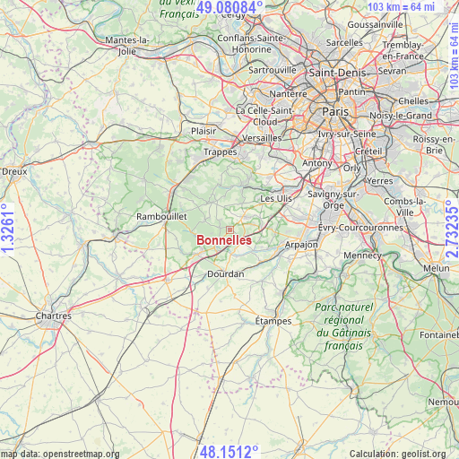
Bonnelles GPS coordinates[2]
48° 37' 5.376" North, 2° 1' 45.192" East
| Map corner | latitude | longitude |
|---|---|---|
| Upper-left | 49.08084°, | 1.3261° |
| Center: | 48.61816°, | 2.02922° |
| Lower-right: | 48.1512°, | 2.73235° |
| Map W x H: | 103.4×103.4 km | = 64.2×64.2mi |
| max Lat: | 51.07786° ⇑28.7% North |
| Bonnelles: | 48.61816° |
| min Lat: | ⇓71.3% South 41.3874° |
| min Long | Bonnelles | max Long |
| -5.08615° | 2.02922° | 9.52242° |
| W 43.2%⇐ | ⇒56.8% E |
Elevation
Elevation of Bonnelles is 121 m = 397 ft, and this is 72.7 m = 239 ft below average elevation for this country.
| Max E: |
2333 m = 7654 ft | 53.3% |
| Avg. | 193.7 m = 635 ft | |
| Bonnelles | 121 m = 397 ft | |
Min E: |
-1 m = -3 ft | 46.7% |
See also: France elevation on elevation.city.
Geographical zone
Bonnelles is located in North temperate zone (between Tropic of Cancer and the Arctic Circle). Distance of this North polar circle is 1995.3 km =1239.8 mi to North.| Distance of | km | miles | from Bonnelles |
|---|---|---|---|
| North Pole | 4601.2 | 2859.1 | to North |
| Arctic Circle | 1995.3 | 1239.8 | to North |
| Tropic Cancer | 2799.9 | 1739.8 | to South |
| Equator | 5405.8 | 3359 | to South |


Nearby cities:
15 places around Bonnelles: (largest is in red/bold)
• Angervilliers
3.9 km =2.4 mi,  136°
136°
• Boullay-les-Troux
6.9 km =4.3 mi,  12°
12°
• Bouville
6.5 km =4 mi,  151°
151°
• Briis-sous-Forges
6.8 km =4.2 mi,  84°
84°
• Bullion
2.9 km =1.8 mi,  280°
280°
• Cernay-la-Ville
7.3 km =4.5 mi,  326°
326°
• Forges-les-Bains
5.5 km =3.4 mi, 76°
• La Celle-les-Bordes
5.9 km =3.7 mi,  289°
289°
• Le Val-Saint-Germain
6.4 km =4 mi,  155°
155°
• Les Molières
6.8 km =4.2 mi,  25°
25°
• Limours
4.7 km =2.9 mi,  48°
48°
• Pecqueuse
3.5 km =2.2 mi,  23°
23°
• Rochefort-en-Yvelines
4.8 km =3 mi,  219°
219°
• Saint-Cyr-sous-Dourdan
5.7 km =3.5 mi,  176°
176°
• Vaugrigneuse
7 km =4.3 mi,  104°
104°
Sources, notices
• [Note1] Compared only with cities in France existing in our database
• [Src1] Map data: © OpenStreetMap contributors (CC-BY-SA)
• [Src2] Other city data from geonames.org with taken over terms of usage.
• [Src3] Geographical zone / Annual Mean Temperature by Robert A. Rohde @ Wikipedia
