Le Coudray-Macouard geodata
Le Coudray-Macouard (Pays de la Loire) is a populated place; located in France in Europe/Paris (GMT+2) time zone. With population of 932 people, there are 9370 cities with bigger population in this country. Compared to other cities in France, 53.1% of cities are located further ↑North; 79% of cities are located further →East and 81.1% of cities have higher elevation than Le Coudray-Macouard. Note1
Administrative division(s):
- Level 1: Pays de la Loire
- Level 2: Département de Maine-et-Loire
- Level 3: Arrondissement de Saumur
- Level 4: Le Coudray-Macouard


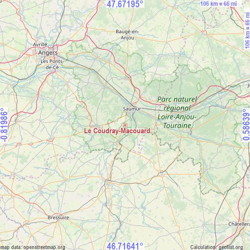
Le Coudray-Macouard GPS coordinates[2]
47° 11' 46.788" North, 0° 7' 0.264" West
| Map corner | latitude | longitude |
|---|---|---|
| Upper-left | 47.67195°, | -0.81986° |
| Center: | 47.19633°, | -0.11674° |
| Lower-right: | 46.71641°, | 0.58639° |
| Map W x H: | 106.2×106.2 km | = 66×66mi |
| max Lat: | 51.07786° ⇑53.1% North |
| Le Coudray-Macouard: | 47.19633° |
| min Lat: | ⇓46.9% South 41.3874° |
| min Long | Le Coudray-Maco | max Long |
| -5.08615° | -0.11674° | 9.52242° |
| W 21%⇐ | ⇒79% E |
Elevation
Elevation of Le Coudray-Macouard is 52 m = 171 ft, and this is 141.7 m = 465 ft below average elevation for this country.
| Max E: |
2333 m = 7654 ft | 81.1% |
| Avg. | 193.7 m = 635 ft | |
| Le Coudray-Macouard | 52 m = 171 ft | |
Min E: |
-1 m = -3 ft | 18.9% |
See also: France elevation on elevation.city.
Geographical zone
Le Coudray-Macouard is located in North temperate zone (between Tropic of Cancer and the Arctic Circle). Distance of this North polar circle is 2153.4 km =1338.1 mi to North.| Distance of | km | miles | from Le Coudray-Macouard |
|---|---|---|---|
| North Pole | 4759.3 | 2957.3 | to North |
| Arctic Circle | 2153.4 | 1338.1 | to North |
| Tropic Cancer | 2641.8 | 1641.5 | to South |
| Equator | 5247.7 | 3260.8 | to South |


Nearby cities:
15 places around Le Coudray-Macouard: (largest is in red/bold)
• Brézé
4.9 km =3 mi,  120°
120°
• Chacé
3.9 km =2.4 mi,  59°
59°
• Distré
3 km =1.9 mi,  8°
8°
• Doué-la-Fontaine
12 km =7.5 mi,  268°
268°
• Le Puy-Notre-Dame
12 km =7.5 mi,  228°
228°
• Les Ulmes
5.3 km =3.3 mi,  298°
298°
• Montreuil-Bellay
7.7 km =4.8 mi,  200°
200°
• Rou-Marson
5.2 km =3.2 mi,  325°
325°
• Saint-Cyr-en-Bourg
4.2 km =2.6 mi,  91°
91°
• Saumur
7.6 km =4.7 mi,  22°
22°
• Souzay-Champigny
9.3 km =5.8 mi, 61°
• Varrains
5.2 km =3.2 mi, 55°
• Vaudelnay
9.4 km =5.8 mi, 226°
• Villebernier
9 km =5.6 mi,  44°
44°
• Épieds
8 km =5 mi,  137°
137°
Sources, notices
• [Note1] Compared only with cities in France existing in our database
• [Src1] Map data: © OpenStreetMap contributors (CC-BY-SA)
• [Src2] Other city data from geonames.org with taken over terms of usage.
• [Src3] Geographical zone / Annual Mean Temperature by Robert A. Rohde @ Wikipedia
