Dogneville geodata
Dogneville (Grand Est) is a populated place; located in France in Europe/Paris (GMT+2) time zone. With population of 1,552 people, there are 6004 cities with bigger population in this country. Compared to other cities in France, 63.2% of cities are located further ↓South; 91.5% of cities are located further ←West and 82.4% of cities have lower elevation than Dogneville. Note1
Administrative division(s):
- Level 1: Grand Est
- Level 2: Vosges
- Level 3: Arrondissement d’Épinal
- Level 4: Dogneville


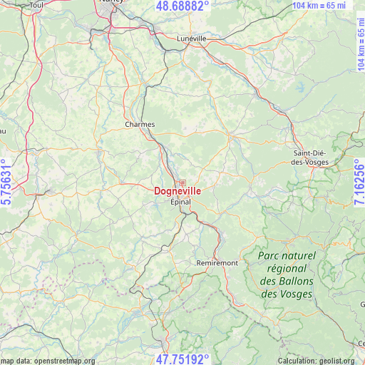
Dogneville GPS coordinates[2]
48° 13' 21.036" North, 6° 27' 33.984" East
| Map corner | latitude | longitude |
|---|---|---|
| Upper-left | 48.68882°, | 5.75631° |
| Center: | 48.22251°, | 6.45944° |
| Lower-right: | 47.75192°, | 7.16256° |
| Map W x H: | 104.2×104.2 km | = 64.7×64.7mi |
| max Lat: | 51.07786° ⇑36.8% North |
| Dogneville: | 48.22251° |
| min Lat: | ⇓63.2% South 41.3874° |
| min Long | Dogneville | max Long |
| -5.08615° | 6.45944° | 9.52242° |
| W 91.5%⇐ | ⇒8.5% E |
Elevation
Elevation of Dogneville is 315 m = 1033 ft, and this is 121.3 m = 398 ft above average elevation for this country.
| Max E: |
2333 m = 7654 ft | 17.6% |
| Dogneville | 315 m 1033 ft | |
| Avg. | 193.7 m = 635 ft | |
Min E: |
-1 m = -3 ft | 82.4% |
See also: France elevation on elevation.city.
Geographical zone
Dogneville is located in North temperate zone (between Tropic of Cancer and the Arctic Circle). Distance of this North polar circle is 2039.3 km =1267.2 mi to North.| Distance of | km | miles | from Dogneville |
|---|---|---|---|
| North Pole | 4645.2 | 2886.4 | to North |
| Arctic Circle | 2039.3 | 1267.2 | to North |
| Tropic Cancer | 2755.9 | 1712.4 | to South |
| Equator | 5361.8 | 3331.7 | to South |


Nearby cities:
15 places around Dogneville: (largest is in red/bold)
• Aydoilles
8.6 km =5.3 mi,  99°
99°
• Chantraine
5.9 km =3.7 mi,  197°
197°
• Chaumousey
10.7 km =6.6 mi,  239°
239°
• Chavelot
2.1 km =1.3 mi,  310°
310°
• Darnieulles
8.6 km =5.3 mi,  252°
252°
• Deyvillers
4.8 km =3 mi,  121°
121°
• Girmont
4.4 km =2.7 mi,  339°
339°
• Golbey
3.1 km =1.9 mi,  207°
207°
• Igney
7.3 km =4.5 mi,  320°
320°
• Jeuxey
3.1 km =1.9 mi,  137°
137°
• Les Forges
7.3 km =4.5 mi,  226°
226°
• Sanchey
8.9 km =5.5 mi, 234°
• Thaon-les-Vosges
4.4 km =2.7 mi, 313°
• Uxegney
7.2 km =4.5 mi, 246°
• Épinal
4.4 km =2.7 mi,  186°
186°
Sources, notices
• [Note1] Compared only with cities in France existing in our database
• [Src1] Map data: © OpenStreetMap contributors (CC-BY-SA)
• [Src2] Other city data from geonames.org with taken over terms of usage.
• [Src3] Geographical zone / Annual Mean Temperature by Robert A. Rohde @ Wikipedia
