Chantraine geodata
Chantraine (Grand Est) is a populated place; located in France in Europe/Paris (GMT+2) time zone. With population of 3,140 people, there are 3098 cities with bigger population in this country. Compared to other cities in France, 62.3% of cities are located further ↓South; 91.3% of cities are located further ←West and 87.7% of cities have lower elevation than Chantraine. Note1
Administrative division(s):
- Level 1: Grand Est
- Level 2: Vosges
- Level 3: Arrondissement d’Épinal
- Level 4: Chantraine


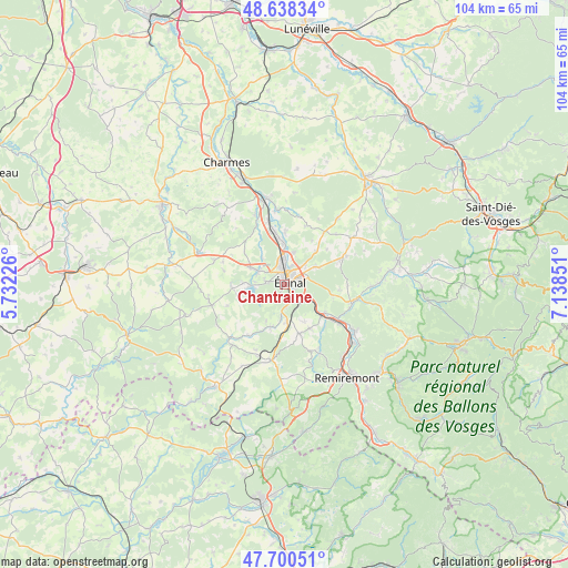
Chantraine GPS coordinates[2]
48° 10' 17.652" North, 6° 26' 7.368" East
| Map corner | latitude | longitude |
|---|---|---|
| Upper-left | 48.63834°, | 5.73226° |
| Center: | 48.17157°, | 6.43538° |
| Lower-right: | 47.70051°, | 7.13851° |
| Map W x H: | 104.3×104.3 km | = 64.8×64.8mi |
| max Lat: | 51.07786° ⇑37.7% North |
| Chantraine: | 48.17157° |
| min Lat: | ⇓62.3% South 41.3874° |
| min Long | Chantraine | max Long |
| -5.08615° | 6.43538° | 9.52242° |
| W 91.3%⇐ | ⇒8.7% E |
Elevation
Elevation of Chantraine is 384 m = 1260 ft, and this is 190.3 m = 624 ft above average elevation for this country.
| Max E: |
2333 m = 7654 ft | 12.3% |
| Chantraine | 384 m 1260 ft | |
| Avg. | 193.7 m = 635 ft | |
Min E: |
-1 m = -3 ft | 87.7% |
See also: France elevation on elevation.city.
Geographical zone
Chantraine is located in North temperate zone (between Tropic of Cancer and the Arctic Circle). Distance of this North polar circle is 2045 km =1270.7 mi to North.| Distance of | km | miles | from Chantraine |
|---|---|---|---|
| North Pole | 4650.9 | 2889.9 | to North |
| Arctic Circle | 2045 | 1270.7 | to North |
| Tropic Cancer | 2750.3 | 1709 | to South |
| Equator | 5356.2 | 3328.2 | to South |


Nearby cities:
15 places around Chantraine: (largest is in red/bold)
• Arches
9.1 km =5.7 mi,  130°
130°
• Chaumousey
7.5 km =4.7 mi,  271°
271°
• Chavelot
7 km =4.3 mi,  1°
1°
• Darnieulles
7.1 km =4.4 mi,  295°
295°
• Deyvillers
6.7 km =4.2 mi,  61°
61°
• Dogneville
5.9 km =3.7 mi,  17°
17°
• Dounoux
7.5 km =4.7 mi,  174°
174°
• Golbey
2.9 km =1.8 mi,  6°
6°
• Jeuxey
5.1 km =3.2 mi,  49°
49°
• Les Forges
3.5 km =2.2 mi,  280°
280°
• Sanchey
5.4 km =3.4 mi, 274°
• Thaon-les-Vosges
8.8 km =5.5 mi,  350°
350°
• Uriménil
8.3 km =5.2 mi,  198°
198°
• Uxegney
5.6 km =3.5 mi, 299°
• Épinal
1.8 km =1.1 mi, 45°
Sources, notices
• [Note1] Compared only with cities in France existing in our database
• [Src1] Map data: © OpenStreetMap contributors (CC-BY-SA)
• [Src2] Other city data from geonames.org with taken over terms of usage.
• [Src3] Geographical zone / Annual Mean Temperature by Robert A. Rohde @ Wikipedia
