Chavelot geodata
Chavelot (Grand Est) is a populated place; located in France in Europe/Paris (GMT+2) time zone. With population of 1,514 people, there are 6145 cities with bigger population in this country. Compared to other cities in France, 63.4% of cities are located further ↓South; 91.3% of cities are located further ←West and 82.6% of cities have lower elevation than Chavelot. Note1
Administrative division(s):
- Level 1: Grand Est
- Level 2: Vosges
- Level 3: Arrondissement d’Épinal
- Level 4: Chavelot


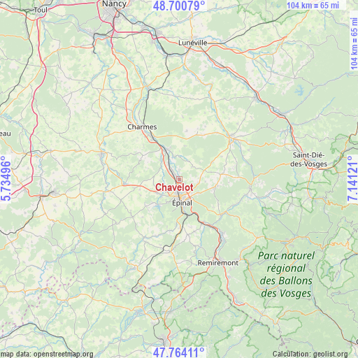
Chavelot GPS coordinates[2]
48° 14' 4.524" North, 6° 26' 17.124" East
| Map corner | latitude | longitude |
|---|---|---|
| Upper-left | 48.70079°, | 5.73496° |
| Center: | 48.23459°, | 6.43809° |
| Lower-right: | 47.76411°, | 7.14121° |
| Map W x H: | 104.1×104.1 km | = 64.7×64.7mi |
| max Lat: | 51.07786° ⇑36.6% North |
| Chavelot: | 48.23459° |
| min Lat: | ⇓63.4% South 41.3874° |
| min Long | Chavelot | max Long |
| -5.08615° | 6.43809° | 9.52242° |
| W 91.3%⇐ | ⇒8.7% E |
Elevation
Elevation of Chavelot is 317 m = 1040 ft, and this is 123.3 m = 405 ft above average elevation for this country.
| Max E: |
2333 m = 7654 ft | 17.4% |
| Chavelot | 317 m 1040 ft | |
| Avg. | 193.7 m = 635 ft | |
Min E: |
-1 m = -3 ft | 82.6% |
See also: France elevation on elevation.city.
Geographical zone
Chavelot is located in North temperate zone (between Tropic of Cancer and the Arctic Circle). Distance of this North polar circle is 2038 km =1266.4 mi to North.| Distance of | km | miles | from Chavelot |
|---|---|---|---|
| North Pole | 4643.9 | 2885.6 | to North |
| Arctic Circle | 2038 | 1266.4 | to North |
| Tropic Cancer | 2757.3 | 1713.3 | to South |
| Equator | 5363.2 | 3332.5 | to South |


Nearby cities:
15 places around Chavelot: (largest is in red/bold)
• Chantraine
7 km =4.3 mi,  181°
181°
• Châtel-sur-Moselle
9.4 km =5.8 mi,  339°
339°
• Darnieulles
7.6 km =4.7 mi,  239°
239°
• Deyvillers
6.9 km =4.3 mi,  123°
123°
• Dogneville
2.1 km =1.3 mi,  130°
130°
• Girmont
2.7 km =1.7 mi,  1°
1°
• Golbey
4.1 km =2.5 mi, 178°
• Igney
5.3 km =3.3 mi,  324°
324°
• Jeuxey
5.2 km =3.2 mi, 134°
• Les Forges
7.3 km =4.5 mi,  210°
210°
• Nomexy
9 km =5.6 mi,  334°
334°
• Sanchey
8.6 km =5.3 mi,  220°
220°
• Thaon-les-Vosges
2.3 km =1.4 mi, 317°
• Uxegney
6.6 km =4.1 mi,  230°
230°
• Épinal
5.8 km =3.6 mi,  169°
169°
Sources, notices
• [Note1] Compared only with cities in France existing in our database
• [Src1] Map data: © OpenStreetMap contributors (CC-BY-SA)
• [Src2] Other city data from geonames.org with taken over terms of usage.
• [Src3] Geographical zone / Annual Mean Temperature by Robert A. Rohde @ Wikipedia
