Dinan geodata
Dinan (Brittany) is a seat of a third-order administrative division; located in France in Europe/Paris (GMT+2) time zone. With population of 12,237 people, there are 785 cities with bigger population in this country. Compared to other cities in France, 67.4% of cities are located further ↓South; 95% of cities are located further →East and 71.4% of cities have higher elevation than Dinan. Note1
Administrative division(s):
- Level 1: Brittany
- Level 2: Département des Côtes-d’Armor
- Level 3: Arrondissement de Dinan
- Level 4: Dinan


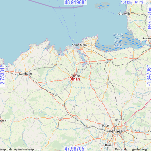
Dinan GPS coordinates[2]
48° 27' 19.836" North, 2° 3' 0.684" West
| Map corner | latitude | longitude |
|---|---|---|
| Upper-left | 48.91968°, | -2.75331° |
| Center: | 48.45551°, | -2.05019° |
| Lower-right: | 47.98705°, | -1.34706° |
| Map W x H: | 103.7×103.7 km | = 64.4×64.4mi |
| max Lat: | 51.07786° ⇑32.6% North |
| Dinan: | 48.45551° |
| min Lat: | ⇓67.4% South 41.3874° |
| min Long | Dinan | max Long |
| -5.08615° | -2.05019° | 9.52242° |
| W 5%⇐ | ⇒95% E |
Elevation
Elevation of Dinan is 75 m = 246 ft, and this is 118.7 m = 389 ft below average elevation for this country.
| Max E: |
2333 m = 7654 ft | 71.4% |
| Avg. | 193.7 m = 635 ft | |
| Dinan | 75 m = 246 ft | |
Min E: |
-1 m = -3 ft | 28.6% |
See also: France elevation on elevation.city.
Geographical zone
Dinan is located in North temperate zone (between Tropic of Cancer and the Arctic Circle). Distance of this North polar circle is 2013.4 km =1251.1 mi to North.| Distance of | km | miles | from Dinan |
|---|---|---|---|
| North Pole | 4619.3 | 2870.3 | to North |
| Arctic Circle | 2013.4 | 1251.1 | to North |
| Tropic Cancer | 2781.8 | 1728.5 | to South |
| Equator | 5387.7 | 3347.8 | to South |


Nearby cities:
15 places around Dinan: (largest is in red/bold)
• Aucaleuc
5.9 km =3.7 mi,  269°
269°
• Bobital
5.8 km =3.6 mi,  219°
219°
• La Vicomté-sur-Rance
6.4 km =4 mi,  51°
51°
• Lanvallay
1.6 km =1 mi,  90°
90°
• Le Hinglé
7.3 km =4.5 mi,  196°
196°
• Les Champs-Géraux
7.3 km =4.5 mi,  126°
126°
• Léhon
1.3 km =0.8 mi,  165°
165°
• Quévert
2.9 km =1.8 mi,  289°
289°
• Saint-Carné
4.6 km =2.9 mi, 196°
• Saint-Hélen
6.9 km =4.3 mi,  76°
76°
• Saint-Samson-sur-Rance
4.4 km =2.7 mi,  21°
21°
• Taden
3.2 km =2 mi, 45°
• Trélivan
5.6 km =3.5 mi,  242°
242°
• Trévron
7.1 km =4.4 mi,  187°
187°
• Vildé-Guingalan
8.2 km =5.1 mi,  255°
255°
Sources, notices
• [Note1] Compared only with cities in France existing in our database
• [Src1] Map data: © OpenStreetMap contributors (CC-BY-SA)
• [Src2] Other city data from geonames.org with taken over terms of usage.
• [Src3] Geographical zone / Annual Mean Temperature by Robert A. Rohde @ Wikipedia
