Saint-Carné geodata
Saint-Carné (Brittany) is a populated place; located in France in Europe/Paris (GMT+2) time zone. With population of 889 people, there are 9749 cities with bigger population in this country. Compared to other cities in France, 66.6% of cities are located further ↓South; 95.1% of cities are located further →East and 60.4% of cities have higher elevation than Saint-Carné. Note1
Administrative division(s):
- Level 1: Brittany
- Level 2: Département des Côtes-d’Armor
- Level 3: Arrondissement de Dinan
- Level 4: Saint-Carné


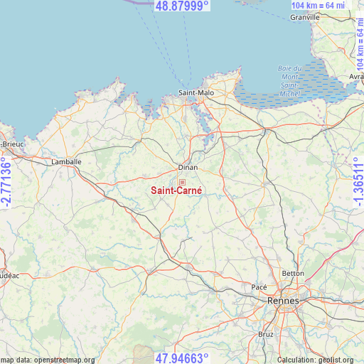
Saint-Carné GPS coordinates[2]
48° 24' 55.62" North, 2° 4' 5.628" West
| Map corner | latitude | longitude |
|---|---|---|
| Upper-left | 48.87999°, | -2.77136° |
| Center: | 48.41545°, | -2.06823° |
| Lower-right: | 47.94663°, | -1.36511° |
| Map W x H: | 103.8×103.8 km | = 64.5×64.5mi |
| max Lat: | 51.07786° ⇑33.4% North |
| Saint-Carné: | 48.41545° |
| min Lat: | ⇓66.6% South 41.3874° |
| min Long | Saint-Carné | max Long |
| -5.08615° | -2.06823° | 9.52242° |
| W 4.9%⇐ | ⇒95.1% E |
Elevation
Elevation of Saint-Carné is 101 m = 331 ft, and this is 92.7 m = 304 ft below average elevation for this country.
| Max E: |
2333 m = 7654 ft | 60.4% |
| Avg. | 193.7 m = 635 ft | |
| Saint-Carné | 101 m = 331 ft | |
Min E: |
-1 m = -3 ft | 39.6% |
See also: France elevation on elevation.city.
Geographical zone
Saint-Carné is located in North temperate zone (between Tropic of Cancer and the Arctic Circle). Distance of this North polar circle is 2017.9 km =1253.9 mi to North.| Distance of | km | miles | from Saint-Carné |
|---|---|---|---|
| North Pole | 4623.8 | 2873.1 | to North |
| Arctic Circle | 2017.9 | 1253.9 | to North |
| Tropic Cancer | 2777.4 | 1725.8 | to South |
| Equator | 5383.3 | 3345 | to South |


Nearby cities:
15 places around Saint-Carné: (largest is in red/bold)
• Aucaleuc
6.3 km =3.9 mi,  313°
313°
• Bobital
2.3 km =1.4 mi,  270°
270°
• Brusvily
5.2 km =3.2 mi,  237°
237°
• Dinan
4.6 km =2.9 mi,  16°
16°
• Lanvallay
5.3 km =3.3 mi,  33°
33°
• Le Hinglé
2.6 km =1.6 mi,  196°
196°
• Les Champs-Géraux
7.2 km =4.5 mi,  89°
89°
• Léhon
3.6 km =2.2 mi, 27°
• Quévert
5.6 km =3.5 mi,  345°
345°
• Saint-Juvat
7.1 km =4.4 mi,  165°
165°
• Taden
7.6 km =4.7 mi, 28°
• Trélivan
4.1 km =2.5 mi,  296°
296°
• Trévron
2.7 km =1.7 mi, 170°
• Vildé-Guingalan
7.1 km =4.4 mi,  290°
290°
• Évran
7.6 km =4.7 mi,  121°
121°
Sources, notices
• [Note1] Compared only with cities in France existing in our database
• [Src1] Map data: © OpenStreetMap contributors (CC-BY-SA)
• [Src2] Other city data from geonames.org with taken over terms of usage.
• [Src3] Geographical zone / Annual Mean Temperature by Robert A. Rohde @ Wikipedia
