Denée geodata
Denée (Pays de la Loire) is a populated place; located in France in Europe/Paris (GMT+2) time zone. With population of 1,467 people, there are 6310 cities with bigger population in this country. Compared to other cities in France, 50.4% of cities are located further ↑North; 84.6% of cities are located further →East and 86.7% of cities have higher elevation than Denée. Note1
Administrative division(s):
- Level 1: Pays de la Loire
- Level 2: Département de Maine-et-Loire
- Level 3: Angers
- Level 4: Denée


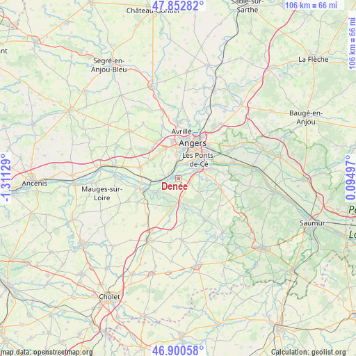
Denée GPS coordinates[2]
47° 22' 43.86" North, 0° 36' 29.376" West
| Map corner | latitude | longitude |
|---|---|---|
| Upper-left | 47.85282°, | -1.31129° |
| Center: | 47.37885°, | -0.60816° |
| Lower-right: | 46.90058°, | 0.09497° |
| Map W x H: | 105.9×105.9 km | = 65.8×65.8mi |
| max Lat: | 51.07786° ⇑50.4% North |
| Denée: | 47.37885° |
| min Lat: | ⇓49.6% South 41.3874° |
| min Long | Denée | max Long |
| -5.08615° | -0.60816° | 9.52242° |
| W 15.4%⇐ | ⇒84.6% E |
Elevation
Elevation of Denée is 38 m = 125 ft, and this is 155.7 m = 511 ft below average elevation for this country.
| Max E: |
2333 m = 7654 ft | 86.7% |
| Avg. | 193.7 m = 635 ft | |
| Denée | 38 m = 125 ft | |
Min E: |
-1 m = -3 ft | 13.3% |
See also: France elevation on elevation.city.
Geographical zone
Denée is located in North temperate zone (between Tropic of Cancer and the Arctic Circle). Distance of this North polar circle is 2133.1 km =1325.4 mi to North.| Distance of | km | miles | from Denée |
|---|---|---|---|
| North Pole | 4739 | 2944.7 | to North |
| Arctic Circle | 2133.1 | 1325.4 | to North |
| Tropic Cancer | 2662.1 | 1654.2 | to South |
| Equator | 5268 | 3273.4 | to South |


Nearby cities:
15 places around Denée: (largest is in red/bold)
• Beaulieu-sur-Layon
7.7 km =4.8 mi,  169°
169°
• Bouchemaine
4.8 km =3 mi,  359°
359°
• Chaudefonds-sur-Layon
9.5 km =5.9 mi,  231°
231°
• La Possonnière
5.8 km =3.6 mi,  265°
265°
• Les Ponts-de-Cé
8 km =5 mi,  51°
51°
• Mozé-sur-Louet
4.7 km =2.9 mi,  118°
118°
• Mûrs-Erigné
5 km =3.1 mi,  61°
61°
• Rochefort-sur-Loire
4.4 km =2.7 mi,  236°
236°
• Saint-Aubin-de-Luigné
7.2 km =4.5 mi,  216°
216°
• Saint-Lambert-du-Lattay
8.7 km =5.4 mi,  192°
192°
• Saint-Martin-du-Fouilloux
9.4 km =5.8 mi,  310°
310°
• Saint-Melaine-sur-Aubance
8.3 km =5.2 mi,  99°
99°
• Sainte-Gemmes-sur-Loire
6.2 km =3.9 mi,  38°
38°
• Savennières
3.7 km =2.3 mi,  275°
275°
• Soulaines-sur-Aubance
6.7 km =4.2 mi, 104°
Sources, notices
• [Note1] Compared only with cities in France existing in our database
• [Src1] Map data: © OpenStreetMap contributors (CC-BY-SA)
• [Src2] Other city data from geonames.org with taken over terms of usage.
• [Src3] Geographical zone / Annual Mean Temperature by Robert A. Rohde @ Wikipedia
