Saint-Erblon geodata
Saint-Erblon (Brittany) is a populated place; located in France in Europe/Paris (GMT+2) time zone. With population of 2,431 people, there are 3983 cities with bigger population in this country. Compared to other cities in France, 59.6% of cities are located further ↓South; 93.2% of cities are located further →East and 87.1% of cities have higher elevation than Saint-Erblon. Note1
Administrative division(s):
- Level 1: Brittany
- Level 2: Département d'Ille-et-Vilaine
- Level 3: Arrondissement de Rennes
- Level 4: Saint-Erblon


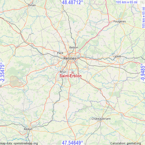
Saint-Erblon GPS coordinates[2]
48° 1' 8.22" North, 1° 39' 5.832" West
| Map corner | latitude | longitude |
|---|---|---|
| Upper-left | 48.48712°, | -2.35475° |
| Center: | 48.01895°, | -1.65162° |
| Lower-right: | 47.54649°, | -0.9485° |
| Map W x H: | 104.6×104.6 km | = 65×65mi |
| max Lat: | 51.07786° ⇑40.4% North |
| Saint-Erblon: | 48.01895° |
| min Lat: | ⇓59.6% South 41.3874° |
| min Long | Saint-Erblon | max Long |
| -5.08615° | -1.65162° | 9.52242° |
| W 6.8%⇐ | ⇒93.2% E |
Elevation
Elevation of Saint-Erblon is 37 m = 121 ft, and this is 156.7 m = 514 ft below average elevation for this country.
| Max E: |
2333 m = 7654 ft | 87.1% |
| Avg. | 193.7 m = 635 ft | |
| Saint-Erblon | 37 m = 121 ft | |
Min E: |
-1 m = -3 ft | 12.9% |
See also: France elevation on elevation.city.
Geographical zone
Saint-Erblon is located in North temperate zone (between Tropic of Cancer and the Arctic Circle). Distance of this North polar circle is 2062 km =1281.3 mi to North.| Distance of | km | miles | from Saint-Erblon |
|---|---|---|---|
| North Pole | 4667.9 | 2900.5 | to North |
| Arctic Circle | 2062 | 1281.3 | to North |
| Tropic Cancer | 2733.3 | 1698.4 | to South |
| Equator | 5339.2 | 3317.6 | to South |


Nearby cities:
15 places around Saint-Erblon: (largest is in red/bold)
• Bourgbarré
3.8 km =2.4 mi,  133°
133°
• Bruz
7 km =4.3 mi,  274°
274°
• Chanteloup
6.5 km =4 mi,  155°
155°
• Chantepie
8.2 km =5.1 mi,  19°
19°
• Chartres-de-Bretagne
4.6 km =2.9 mi,  299°
299°
• Châtillon-sur-Seiche
2.3 km =1.4 mi,  319°
319°
• Corps-Nuds
6.7 km =4.2 mi, 131°
• Crevin
9.6 km =6 mi,  186°
186°
• Laillé
6.6 km =4.1 mi,  227°
227°
• Nouvoitou
8.1 km =5 mi,  72°
72°
• Orgères
2.5 km =1.6 mi,  208°
208°
• Rennes
10.5 km =6.5 mi,  350°
350°
• Saint-Armel
4.5 km =2.8 mi,  98°
98°
• Saint-Jacques-de-la-Lande
7.3 km =4.5 mi,  314°
314°
• Vern-sur-Seiche
4.8 km =3 mi,  52°
52°
Sources, notices
• [Note1] Compared only with cities in France existing in our database
• [Src1] Map data: © OpenStreetMap contributors (CC-BY-SA)
• [Src2] Other city data from geonames.org with taken over terms of usage.
• [Src3] Geographical zone / Annual Mean Temperature by Robert A. Rohde @ Wikipedia
