Crespières geodata
Crespières (Île-de-France) is a populated place; located in France in Europe/Paris (GMT+2) time zone. With population of 1,554 people, there are 5996 cities with bigger population in this country. Compared to other cities in France, 77.2% of cities are located further ↓South; 58% of cities are located further →East and 55.2% of cities have higher elevation than Crespières. Note1
Administrative division(s):
- Level 1: Île-de-France
- Level 2: Yvelines
- Level 3: Arrondissement de Saint-Germain-en-Laye
- Level 4: Crespières


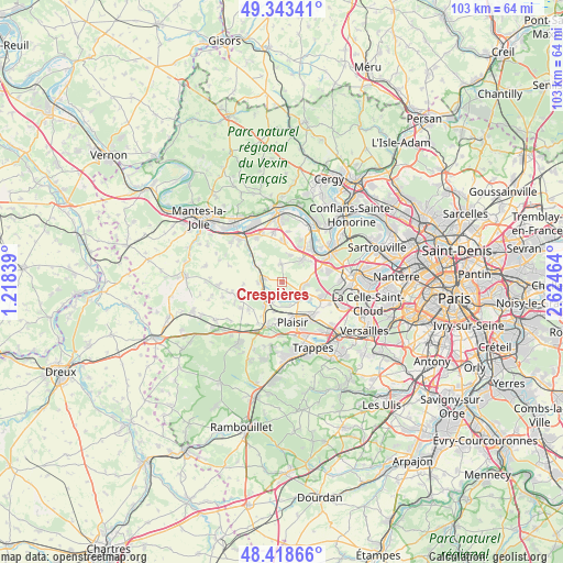
Crespières GPS coordinates[2]
48° 52' 59.412" North, 1° 55' 17.436" East
| Map corner | latitude | longitude |
|---|---|---|
| Upper-left | 49.34341°, | 1.21839° |
| Center: | 48.88317°, | 1.92151° |
| Lower-right: | 48.41866°, | 2.62464° |
| Map W x H: | 102.8×102.8 km | = 63.9×63.9mi |
| max Lat: | 51.07786° ⇑22.8% North |
| Crespières: | 48.88317° |
| min Lat: | ⇓77.2% South 41.3874° |
| min Long | Crespières | max Long |
| -5.08615° | 1.92151° | 9.52242° |
| W 42%⇐ | ⇒58% E |
Elevation
Elevation of Crespières is 116 m = 381 ft, and this is 77.7 m = 255 ft below average elevation for this country.
| Max E: |
2333 m = 7654 ft | 55.2% |
| Avg. | 193.7 m = 635 ft | |
| Crespières | 116 m = 381 ft | |
Min E: |
-1 m = -3 ft | 44.8% |
See also: France elevation on elevation.city.
Geographical zone
Crespières is located in North temperate zone (between Tropic of Cancer and the Arctic Circle). Distance of this North polar circle is 1965.9 km =1221.6 mi to North.| Distance of | km | miles | from Crespières |
|---|---|---|---|
| North Pole | 4571.8 | 2840.8 | to North |
| Arctic Circle | 1965.9 | 1221.6 | to North |
| Tropic Cancer | 2829.4 | 1758.1 | to South |
| Equator | 5435.3 | 3377.3 | to South |


Nearby cities:
15 places around Crespières: (largest is in red/bold)
• Aigremont
7.5 km =4.7 mi,  71°
71°
• Bazemont
6.3 km =3.9 mi,  320°
320°
• Beynes
4.7 km =2.9 mi,  230°
230°
• Chavenay
6 km =3.7 mi,  121°
121°
• Ecquevilly
7.6 km =4.7 mi,  1°
1°
• Feucherolles
4.1 km =2.5 mi,  110°
110°
• Les Alluets-le-Roi
3.4 km =2.1 mi,  355°
355°
• Mareil-sur-Mauldre
4.1 km =2.5 mi,  289°
289°
• Maule
5.9 km =3.7 mi,  301°
301°
• Montainville
4.4 km =2.7 mi,  269°
269°
• Morainvilliers
5.2 km =3.2 mi,  11°
11°
• Orgeval
5.9 km =3.7 mi,  43°
43°
• Plaisir
7.1 km =4.4 mi,  160°
160°
• Saint-Germain-de-la-Grange
5.7 km =3.5 mi,  196°
196°
• Thiverval-Grignon
3.7 km =2.3 mi,  184°
184°
Sources, notices
• [Note1] Compared only with cities in France existing in our database
• [Src1] Map data: © OpenStreetMap contributors (CC-BY-SA)
• [Src2] Other city data from geonames.org with taken over terms of usage.
• [Src3] Geographical zone / Annual Mean Temperature by Robert A. Rohde @ Wikipedia
