Beynes geodata
Beynes (Île-de-France) is a populated place; located in France in Europe/Paris (GMT+2) time zone. With population of 7,914 people, there are 1224 cities with bigger population in this country. Compared to other cities in France, 76.8% of cities are located further ↓South; 58.6% of cities are located further →East and 80.2% of cities have higher elevation than Beynes. Note1
Administrative division(s):
- Level 1: Île-de-France
- Level 2: Yvelines
- Level 3: Arrondissement de Rambouillet
- Level 4: Beynes


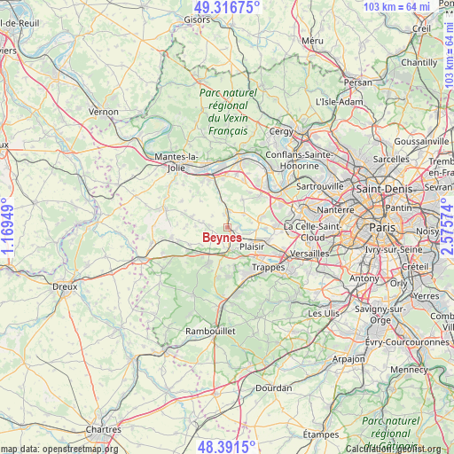
Beynes GPS coordinates[2]
48° 51' 22.536" North, 1° 52' 21.396" East
| Map corner | latitude | longitude |
|---|---|---|
| Upper-left | 49.31675°, | 1.16949° |
| Center: | 48.85626°, | 1.87261° |
| Lower-right: | 48.3915°, | 2.57574° |
| Map W x H: | 102.9×102.9 km | = 63.9×63.9mi |
| max Lat: | 51.07786° ⇑23.2% North |
| Beynes: | 48.85626° |
| min Lat: | ⇓76.8% South 41.3874° |
| min Long | Beynes | max Long |
| -5.08615° | 1.87261° | 9.52242° |
| W 41.4%⇐ | ⇒58.6% E |
Elevation
Elevation of Beynes is 54 m = 177 ft, and this is 139.7 m = 458 ft below average elevation for this country.
| Max E: |
2333 m = 7654 ft | 80.2% |
| Avg. | 193.7 m = 635 ft | |
| Beynes | 54 m = 177 ft | |
Min E: |
-1 m = -3 ft | 19.8% |
See also: France elevation on elevation.city.
Geographical zone
Beynes is located in North temperate zone (between Tropic of Cancer and the Arctic Circle). Distance of this North polar circle is 1968.9 km =1223.4 mi to North.| Distance of | km | miles | from Beynes |
|---|---|---|---|
| North Pole | 4574.8 | 2842.6 | to North |
| Arctic Circle | 1968.9 | 1223.4 | to North |
| Tropic Cancer | 2826.4 | 1756.2 | to South |
| Equator | 5432.3 | 3375.5 | to South |


Nearby cities:
15 places around Beynes: (largest is in red/bold)
• Auteuil
4.4 km =2.7 mi,  247°
247°
• Boissy-sans-Avoir
6.9 km =4.3 mi,  230°
230°
• Crespières
4.7 km =2.9 mi,  50°
50°
• Marcq
3.5 km =2.2 mi,  274°
274°
• Mareil-sur-Mauldre
4.3 km =2.7 mi,  356°
356°
• Maule
6.2 km =3.9 mi,  346°
346°
• Montainville
3 km =1.9 mi,  343°
343°
• Neauphle-le-Château
5.3 km =3.3 mi,  152°
152°
• Neauphle-le-Vieux
4.6 km =2.9 mi,  189°
189°
• Plaisir
7 km =4.3 mi,  121°
121°
• Saint-Germain-de-la-Grange
3.1 km =1.9 mi,  141°
141°
• Saulx-Marchais
3.3 km =2.1 mi, 231°
• Thiverval-Grignon
3.4 km =2.1 mi,  102°
102°
• Thoiry
5.6 km =3.5 mi,  282°
282°
• Villiers-Saint-Fréderic
4.5 km =2.8 mi,  169°
169°
Sources, notices
• [Note1] Compared only with cities in France existing in our database
• [Src1] Map data: © OpenStreetMap contributors (CC-BY-SA)
• [Src2] Other city data from geonames.org with taken over terms of usage.
• [Src3] Geographical zone / Annual Mean Temperature by Robert A. Rohde @ Wikipedia
