Cambernon geodata
Cambernon (Normandy) is a populated place; located in France in Europe/Paris (GMT+2) time zone. With population of 711 people, there are 11641 cities with bigger population in this country. Compared to other cities in France, 81.7% of cities are located further ↓South; 91.4% of cities are located further →East and 53.3% of cities have lower elevation than Cambernon. Note1
Administrative division(s):
- Level 1: Normandy
- Level 2: Manche
- Level 3: Arrondissement de Coutances
- Level 4: Cambernon


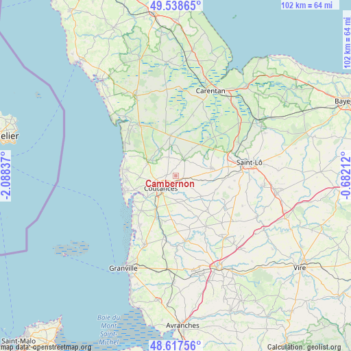
Cambernon GPS coordinates[2]
49° 4' 48.864" North, 1° 23' 6.864" West
| Map corner | latitude | longitude |
|---|---|---|
| Upper-left | 49.53865°, | -2.08837° |
| Center: | 49.08024°, | -1.38524° |
| Lower-right: | 48.61756°, | -0.68212° |
| Map W x H: | 102.4×102.4 km | = 63.6×63.6mi |
| max Lat: | 51.07786° ⇑18.3% North |
| Cambernon: | 49.08024° |
| min Lat: | ⇓81.7% South 41.3874° |
| min Long | Cambernon | max Long |
| -5.08615° | -1.38524° | 9.52242° |
| W 8.6%⇐ | ⇒91.4% E |
Elevation
Elevation of Cambernon is 144 m = 472 ft, and this is 49.7 m = 163 ft below average elevation for this country.
| Max E: |
2333 m = 7654 ft | 46.7% |
| Avg. | 193.7 m = 635 ft | |
| Cambernon | 144 m = 472 ft | |
Min E: |
-1 m = -3 ft | 53.3% |
See also: France elevation on elevation.city.
Geographical zone
Cambernon is located in North temperate zone (between Tropic of Cancer and the Arctic Circle). Distance of this North polar circle is 1944 km =1207.9 mi to North.| Distance of | km | miles | from Cambernon |
|---|---|---|---|
| North Pole | 4549.9 | 2827.2 | to North |
| Arctic Circle | 1944 | 1207.9 | to North |
| Tropic Cancer | 2851.3 | 1771.7 | to South |
| Equator | 5457.2 | 3390.9 | to South |


Nearby cities:
15 places around Cambernon: (largest is in red/bold)
• Bricqueville-la-Blouette
8.6 km =5.3 mi,  233°
233°
• Carantilly
10.7 km =6.6 mi,  98°
98°
• Cerisy-la-Salle
9.6 km =6 mi,  128°
128°
• Coutances
5.8 km =3.6 mi, 228°
• Gratot
7.1 km =4.4 mi,  259°
259°
• Le Lorey
5.9 km =3.7 mi,  75°
75°
• Marigny
10.7 km =6.6 mi, 78°
• Monthuchon
2.8 km =1.7 mi,  271°
271°
• Montpinchon
8.5 km =5.3 mi,  140°
140°
• Muneville-le-Bingard
8.2 km =5.1 mi,  303°
303°
• Orval
9.6 km =6 mi,  220°
220°
• Roncey
10.8 km =6.7 mi,  159°
159°
• Saint-Denis-le-Vêtu
10.5 km =6.5 mi,  187°
187°
• Saint-Sauveur-Lendelin
5.9 km =3.7 mi,  339°
339°
• Saussey
8.6 km =5.3 mi,  203°
203°
Sources, notices
• [Note1] Compared only with cities in France existing in our database
• [Src1] Map data: © OpenStreetMap contributors (CC-BY-SA)
• [Src2] Other city data from geonames.org with taken over terms of usage.
• [Src3] Geographical zone / Annual Mean Temperature by Robert A. Rohde @ Wikipedia
