Cours-de-Pile geodata
Cours-de-Pile (Nouvelle-Aquitaine) is a populated place; located in France in Europe/Paris (GMT+2) time zone. With population of 1,395 people, there are 6627 cities with bigger population in this country. Compared to other cities in France, 81% of cities are located further ↑North; 73% of cities are located further →East and 83.8% of cities have higher elevation than Cours-de-Pile. Note1
Administrative division(s):
- Level 1: Nouvelle-Aquitaine
- Level 2: Dordogne
- Level 3: Arrondissement de Bergerac
- Level 4: Cours-de-Pile


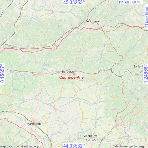
Cours-de-Pile GPS coordinates[2]
44° 50' 9.888" North, 0° 32' 47.616" East
| Map corner | latitude | longitude |
|---|---|---|
| Upper-left | 45.33253°, | -0.15657° |
| Center: | 44.83608°, | 0.54656° |
| Lower-right: | 44.33532°, | 1.24969° |
| Map W x H: | 110.9×110.9 km | = 68.9×68.9mi |
| max Lat: | 51.07786° ⇑81% North |
| Cours-de-Pile: | 44.83608° |
| min Lat: | ⇓19% South 41.3874° |
| min Long | Cours-de-Pile | max Long |
| -5.08615° | 0.54656° | 9.52242° |
| W 27%⇐ | ⇒73% E |
Elevation
Elevation of Cours-de-Pile is 45 m = 148 ft, and this is 148.7 m = 488 ft below average elevation for this country.
| Max E: |
2333 m = 7654 ft | 83.8% |
| Avg. | 193.7 m = 635 ft | |
| Cours-de-Pile | 45 m = 148 ft | |
Min E: |
-1 m = -3 ft | 16.2% |
See also: France elevation on elevation.city.
Geographical zone
Cours-de-Pile is located in North temperate zone (between Tropic of Cancer and the Arctic Circle). Distance of this Northern Tropic circle is 2379.4 km =1478.5 mi to South.| Distance of | km | miles | from Cours-de-Pile |
|---|---|---|---|
| North Pole | 5021.8 | 3120.4 | to North |
| Arctic Circle | 2415.9 | 1501.2 | to North |
| Tropic Cancer | 2379.4 | 1478.5 | to South |
| Equator | 4985.3 | 3097.7 | to South |


Nearby cities:
15 places around Cours-de-Pile: (largest is in red/bold)
• Bergerac
5.4 km =3.4 mi,  288°
288°
• Bouniagues
8.7 km =5.4 mi,  190°
190°
• Creysse
2.6 km =1.6 mi,  36°
36°
• Lamonzie-Montastruc
7.6 km =4.7 mi,  29°
29°
• Lanquais
9.9 km =6.2 mi,  98°
98°
• Lembras
5.6 km =3.5 mi,  343°
343°
• Monbazillac
6.3 km =3.9 mi,  222°
222°
• Mouleydier
4.6 km =2.9 mi,  61°
61°
• Pomport
11.9 km =7.4 mi,  237°
237°
• Prigonrieux
11.5 km =7.1 mi,  280°
280°
• Queyssac
8 km =5 mi,  0°
0°
• Saint-Capraise-de-Lalinde
8.5 km =5.3 mi,  85°
85°
• Saint-Laurent-des-Vignes
7.6 km =4.7 mi,  253°
253°
• Saint-Nexans
3.7 km =2.3 mi,  177°
177°
• Saint-Sauveur
4.8 km =3 mi, 40°
Sources, notices
• [Note1] Compared only with cities in France existing in our database
• [Src1] Map data: © OpenStreetMap contributors (CC-BY-SA)
• [Src2] Other city data from geonames.org with taken over terms of usage.
• [Src3] Geographical zone / Annual Mean Temperature by Robert A. Rohde @ Wikipedia
