Bergerac geodata
Bergerac (Nouvelle-Aquitaine) is a seat of a third-order administrative division; located in France in Europe/Paris (GMT+2) time zone. With population of 28,317 people, there are 299 cities with bigger population in this country. Compared to other cities in France, 80.9% of cities are located further ↑North; 73.5% of cities are located further →East and 86.7% of cities have higher elevation than Bergerac. Note1
Administrative division(s):
- Level 1: Nouvelle-Aquitaine
- Level 2: Dordogne
- Level 3: Arrondissement de Bergerac
- Level 4: Bergerac


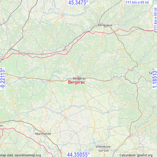
Bergerac GPS coordinates[2]
44° 51' 4.248" North, 0° 28' 55.2" East
| Map corner | latitude | longitude |
|---|---|---|
| Upper-left | 45.3475°, | -0.22113° |
| Center: | 44.85118°, | 0.482° |
| Lower-right: | 44.35055°, | 1.18513° |
| Map W x H: | 110.9×110.8 km | = 68.9×68.8mi |
| max Lat: | 51.07786° ⇑80.9% North |
| Bergerac: | 44.85118° |
| min Lat: | ⇓19.1% South 41.3874° |
| min Long | Bergerac | max Long |
| -5.08615° | 0.482° | 9.52242° |
| W 26.5%⇐ | ⇒73.5% E |
Elevation
Elevation of Bergerac is 38 m = 125 ft, and this is 155.7 m = 511 ft below average elevation for this country.
| Max E: |
2333 m = 7654 ft | 86.7% |
| Avg. | 193.7 m = 635 ft | |
| Bergerac | 38 m = 125 ft | |
Min E: |
-1 m = -3 ft | 13.3% |
See also: France elevation on elevation.city.
Geographical zone
Bergerac is located in North temperate zone (between Tropic of Cancer and the Arctic Circle). Distance of this Northern Tropic circle is 2381.1 km =1479.5 mi to South.| Distance of | km | miles | from Bergerac |
|---|---|---|---|
| North Pole | 5020.1 | 3119.3 | to North |
| Arctic Circle | 2414.2 | 1500.1 | to North |
| Tropic Cancer | 2381.1 | 1479.5 | to South |
| Equator | 4987 | 3098.8 | to South |


Nearby cities:
15 places around Bergerac: (largest is in red/bold)
• Cours-de-Pile
5.4 km =3.4 mi,  108°
108°
• Creysse
6.6 km =4.1 mi,  86°
86°
• Ginestet
7.7 km =4.8 mi,  327°
327°
• La Force
8.6 km =5.3 mi,  283°
283°
• Lamonzie-Saint-Martin
7.2 km =4.5 mi,  266°
266°
• Lembras
5.1 km =3.2 mi,  43°
43°
• Maurens
9.3 km =5.8 mi,  0°
0°
• Monbazillac
6.4 km =4 mi,  172°
172°
• Mouleydier
9.1 km =5.7 mi, 86°
• Pomport
9.5 km =5.9 mi,  212°
212°
• Prigonrieux
6.3 km =3.9 mi, 273°
• Queyssac
8.2 km =5.1 mi, 39°
• Saint-Laurent-des-Vignes
4.4 km =2.7 mi, 209°
• Saint-Nexans
7.5 km =4.7 mi,  135°
135°
• Saint-Sauveur
8.4 km =5.2 mi,  76°
76°
Sources, notices
• [Note1] Compared only with cities in France existing in our database
• [Src1] Map data: © OpenStreetMap contributors (CC-BY-SA)
• [Src2] Other city data from geonames.org with taken over terms of usage.
• [Src3] Geographical zone / Annual Mean Temperature by Robert A. Rohde @ Wikipedia
