Tavernes geodata
Tavernes (Provence-Alpes-Côte d'Azur) is a populated place; located in France in Europe/Paris (GMT+2) time zone. With population of 977 people, there are 9003 cities with bigger population in this country. Compared to other cities in France, 91.9% of cities are located further ↑North; 87.2% of cities are located further ←West and 87% of cities have lower elevation than Tavernes. Note1
Administrative division(s):
- Level 1: Provence-Alpes-Côte d'Azur
- Level 2: Var
- Level 3: Arrondissement de Brignoles
- Level 4: Tavernes


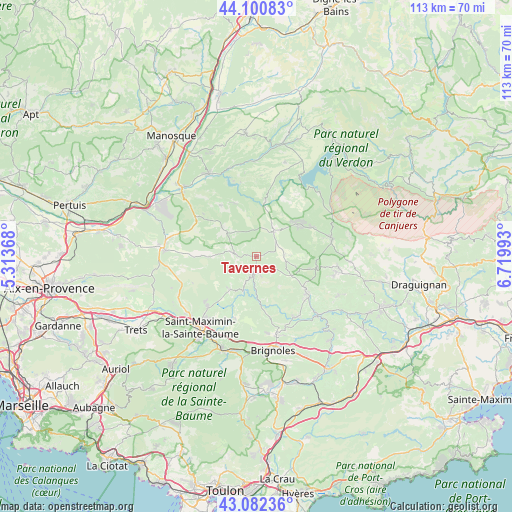
Tavernes GPS coordinates[2]
43° 35' 37.5" North, 6° 1' 0.48" East
| Map corner | latitude | longitude |
|---|---|---|
| Upper-left | 44.10083°, | 5.31368° |
| Center: | 43.59375°, | 6.0168° |
| Lower-right: | 43.08236°, | 6.71993° |
| Map W x H: | 113.2×113.2 km | = 70.3×70.3mi |
| max Lat: | 51.07786° ⇑91.9% North |
| Tavernes: | 43.59375° |
| min Lat: | ⇓8.1% South 41.3874° |
| min Long | Tavernes | max Long |
| -5.08615° | 6.0168° | 9.52242° |
| W 87.2%⇐ | ⇒12.8% E |
Elevation
Elevation of Tavernes is 374 m = 1227 ft, and this is 180.3 m = 592 ft above average elevation for this country.
| Max E: |
2333 m = 7654 ft | 13% |
| Tavernes | 374 m 1227 ft | |
| Avg. | 193.7 m = 635 ft | |
Min E: |
-1 m = -3 ft | 87% |
See also: France elevation on elevation.city.
Geographical zone
Tavernes is located in North temperate zone (between Tropic of Cancer and the Arctic Circle). Distance of this Northern Tropic circle is 2241.3 km =1392.7 mi to South.| Distance of | km | miles | from Tavernes |
|---|---|---|---|
| North Pole | 5159.9 | 3206.2 | to North |
| Arctic Circle | 2554 | 1587 | to North |
| Tropic Cancer | 2241.3 | 1392.7 | to South |
| Equator | 4847.2 | 3011.9 | to South |


Nearby cities:
15 places around Tavernes: (largest is in red/bold)
• Aups
17.2 km =10.7 mi,  77°
77°
• Barjols
4 km =2.5 mi,  190°
190°
• Bras
14.5 km =9 mi,  200°
200°
• Brue-Auriac
9.4 km =5.8 mi,  219°
219°
• Correns
12.8 km =8 mi,  156°
156°
• Cotignac
12.9 km =8 mi,  124°
124°
• Ginasservis
16 km =9.9 mi,  302°
302°
• La Verdière
8.3 km =5.2 mi,  307°
307°
• Montfort-sur-Argens
15.8 km =9.8 mi,  148°
148°
• Pontevès
4.6 km =2.9 mi,  167°
167°
• Régusse
11.5 km =7.1 mi,  53°
53°
• Saint-Julien
14 km =8.7 mi,  320°
320°
• Salernes
17.8 km =11.1 mi,  100°
100°
• Sillans-la-Cascade
13.4 km =8.3 mi, 102°
• Varages
4.6 km =2.9 mi,  275°
275°
Sources, notices
• [Note1] Compared only with cities in France existing in our database
• [Src1] Map data: © OpenStreetMap contributors (CC-BY-SA)
• [Src2] Other city data from geonames.org with taken over terms of usage.
• [Src3] Geographical zone / Annual Mean Temperature by Robert A. Rohde @ Wikipedia
