Cornillé geodata
Cornillé (Brittany) is a populated place; located in France in Europe/Paris (GMT+2) time zone. With population of 769 people, there are 10958 cities with bigger population in this country. Compared to other cities in France, 60.8% of cities are located further ↓South; 90.8% of cities are located further →East and 61.2% of cities have higher elevation than Cornillé. Note1
Administrative division(s):
- Level 1: Brittany
- Level 2: Département d'Ille-et-Vilaine
- Level 3: Arrondissement de Fougères-Vitré
- Level 4: Cornillé


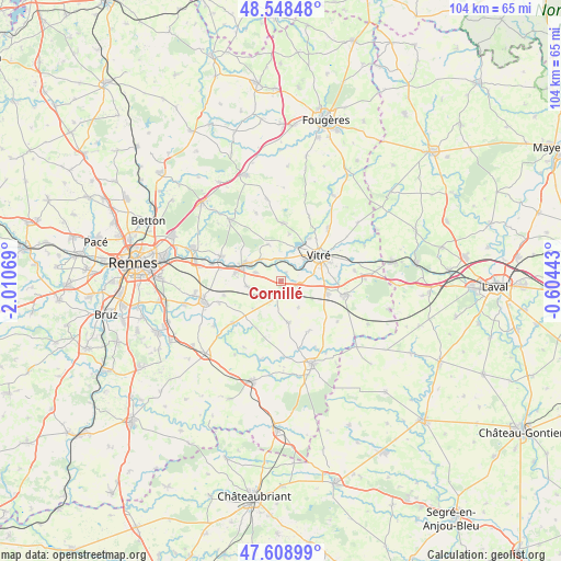
Cornillé GPS coordinates[2]
48° 4' 51.168" North, 1° 18' 27.216" West
| Map corner | latitude | longitude |
|---|---|---|
| Upper-left | 48.54848°, | -2.01069° |
| Center: | 48.08088°, | -1.30756° |
| Lower-right: | 47.60899°, | -0.60443° |
| Map W x H: | 104.5×104.5 km | = 64.9×64.9mi |
| max Lat: | 51.07786° ⇑39.2% North |
| Cornillé: | 48.08088° |
| min Lat: | ⇓60.8% South 41.3874° |
| min Long | Cornillé | max Long |
| -5.08615° | -1.30756° | 9.52242° |
| W 9.2%⇐ | ⇒90.8% E |
Elevation
Elevation of Cornillé is 99 m = 325 ft, and this is 94.7 m = 311 ft below average elevation for this country.
| Max E: |
2333 m = 7654 ft | 61.2% |
| Avg. | 193.7 m = 635 ft | |
| Cornillé | 99 m = 325 ft | |
Min E: |
-1 m = -3 ft | 38.8% |
See also: France elevation on elevation.city.
Geographical zone
Cornillé is located in North temperate zone (between Tropic of Cancer and the Arctic Circle). Distance of this North polar circle is 2055.1 km =1277 mi to North.| Distance of | km | miles | from Cornillé |
|---|---|---|---|
| North Pole | 4661 | 2896.2 | to North |
| Arctic Circle | 2055.1 | 1277 | to North |
| Tropic Cancer | 2740.2 | 1702.7 | to South |
| Equator | 5346.1 | 3321.9 | to South |


Nearby cities:
15 places around Cornillé: (largest is in red/bold)
• Bais
8 km =5 mi,  170°
170°
• Châteaubourg
7.7 km =4.8 mi,  296°
296°
• Domagné
6.4 km =4 mi,  259°
259°
• Louvigné-de-Bais
3.9 km =2.4 mi,  206°
206°
• Marpiré
7.2 km =4.5 mi,  340°
340°
• Montreuil-sous-Pérouse
9.4 km =5.8 mi,  32°
32°
• Moulins
9.9 km =6.2 mi, 209°
• Pocé-les-Bois
5.7 km =3.5 mi,  46°
46°
• Saint-Aubin-des-Landes
1.8 km =1.1 mi, 29°
• Saint-Didier
5.1 km =3.2 mi,  288°
288°
• Saint-Jean-sur-Vilaine
5.6 km =3.5 mi,  314°
314°
• Torcé
3.7 km =2.3 mi,  126°
126°
• Vergéal
5.8 km =3.6 mi,  147°
147°
• Vitré
8.6 km =5.3 mi,  61°
61°
• Étrelles
8.7 km =5.4 mi,  105°
105°
Sources, notices
• [Note1] Compared only with cities in France existing in our database
• [Src1] Map data: © OpenStreetMap contributors (CC-BY-SA)
• [Src2] Other city data from geonames.org with taken over terms of usage.
• [Src3] Geographical zone / Annual Mean Temperature by Robert A. Rohde @ Wikipedia
