Vergéal geodata
Vergéal (Brittany) is a populated place; located in France in Europe/Paris (GMT+2) time zone. With population of 644 people, there are 12610 cities with bigger population in this country. Compared to other cities in France, 59.9% of cities are located further ↓South; 90.5% of cities are located further →East and 66.6% of cities have higher elevation than Vergéal. Note1
Administrative division(s):
- Level 1: Brittany
- Level 2: Département d'Ille-et-Vilaine
- Level 3: Arrondissement de Fougères-Vitré
- Level 4: Vergéal


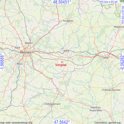
Vergéal GPS coordinates[2]
48° 2' 11.4" North, 1° 15' 56.7" West
| Map corner | latitude | longitude |
|---|---|---|
| Upper-left | 48.50451°, | -1.96888° |
| Center: | 48.0365°, | -1.26575° |
| Lower-right: | 47.5642°, | -0.56262° |
| Map W x H: | 104.6×104.6 km | = 65×65mi |
| max Lat: | 51.07786° ⇑40.1% North |
| Vergéal: | 48.0365° |
| min Lat: | ⇓59.9% South 41.3874° |
| min Long | Vergéal | max Long |
| -5.08615° | -1.26575° | 9.52242° |
| W 9.5%⇐ | ⇒90.5% E |
Elevation
Elevation of Vergéal is 86 m = 282 ft, and this is 107.7 m = 353 ft below average elevation for this country.
| Max E: |
2333 m = 7654 ft | 66.6% |
| Avg. | 193.7 m = 635 ft | |
| Vergéal | 86 m = 282 ft | |
Min E: |
-1 m = -3 ft | 33.4% |
See also: France elevation on elevation.city.
Geographical zone
Vergéal is located in North temperate zone (between Tropic of Cancer and the Arctic Circle). Distance of this North polar circle is 2060 km =1280 mi to North.| Distance of | km | miles | from Vergéal |
|---|---|---|---|
| North Pole | 4665.9 | 2899.3 | to North |
| Arctic Circle | 2060 | 1280 | to North |
| Tropic Cancer | 2735.2 | 1699.6 | to South |
| Equator | 5341.2 | 3318.9 | to South |


Nearby cities:
15 places around Vergéal: (largest is in red/bold)
• Argentré-du-Plessis
9.2 km =5.7 mi,  75°
75°
• Availles-sur-Seiche
9.8 km =6.1 mi,  148°
148°
• Bais
3.5 km =2.2 mi,  210°
210°
• Cornillé
5.8 km =3.6 mi,  327°
327°
• Domalain
4.8 km =3 mi,  158°
158°
• Louvigné-de-Bais
5 km =3.1 mi,  285°
285°
• Moulins
8.8 km =5.5 mi,  244°
244°
• Moutiers
8.7 km =5.4 mi, 153°
• Pocé-les-Bois
8.9 km =5.5 mi,  6°
6°
• Saint-Aubin-des-Landes
6.9 km =4.3 mi,  341°
341°
• Saint-Germain-du-Pinel
7.8 km =4.8 mi,  110°
110°
• Torcé
2.7 km =1.7 mi,  357°
357°
• Visseiche
9.4 km =5.8 mi,  196°
196°
• Vitré
10.1 km =6.3 mi,  26°
26°
• Étrelles
6 km =3.7 mi,  63°
63°
Sources, notices
• [Note1] Compared only with cities in France existing in our database
• [Src1] Map data: © OpenStreetMap contributors (CC-BY-SA)
• [Src2] Other city data from geonames.org with taken over terms of usage.
• [Src3] Geographical zone / Annual Mean Temperature by Robert A. Rohde @ Wikipedia
