Châteaubourg geodata
Châteaubourg (Brittany) is a populated place; located in France in Europe/Paris (GMT+2) time zone. With population of 5,362 people, there are 1838 cities with bigger population in this country. Compared to other cities in France, 61.4% of cities are located further ↓South; 91.5% of cities are located further →East and 81.8% of cities have higher elevation than Châteaubourg. Note1
Administrative division(s):
- Level 1: Brittany
- Level 2: Département d'Ille-et-Vilaine
- Level 3: Arrondissement de Fougères-Vitré
- Level 4: Châteaubourg


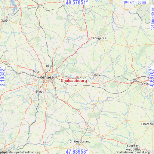
Châteaubourg GPS coordinates[2]
48° 6' 40.284" North, 1° 24' 0.684" West
| Map corner | latitude | longitude |
|---|---|---|
| Upper-left | 48.57851°, | -2.10332° |
| Center: | 48.11119°, | -1.40019° |
| Lower-right: | 47.63958°, | -0.69707° |
| Map W x H: | 104.4×104.4 km | = 64.9×64.9mi |
| max Lat: | 51.07786° ⇑38.6% North |
| Châteaubourg: | 48.11119° |
| min Lat: | ⇓61.4% South 41.3874° |
| min Long | Châteaubourg | max Long |
| -5.08615° | -1.40019° | 9.52242° |
| W 8.5%⇐ | ⇒91.5% E |
Elevation
Elevation of Châteaubourg is 50 m = 164 ft, and this is 143.7 m = 471 ft below average elevation for this country.
| Max E: |
2333 m = 7654 ft | 81.8% |
| Avg. | 193.7 m = 635 ft | |
| Châteaubourg | 50 m = 164 ft | |
Min E: |
-1 m = -3 ft | 18.2% |
See also: France elevation on elevation.city.
Geographical zone
Châteaubourg is located in North temperate zone (between Tropic of Cancer and the Arctic Circle). Distance of this North polar circle is 2051.7 km =1274.9 mi to North.| Distance of | km | miles | from Châteaubourg |
|---|---|---|---|
| North Pole | 4657.6 | 2894.1 | to North |
| Arctic Circle | 2051.7 | 1274.9 | to North |
| Tropic Cancer | 2743.5 | 1704.7 | to South |
| Equator | 5349.5 | 3324 | to South |


Nearby cities:
15 places around Châteaubourg: (largest is in red/bold)
• Acigné
10.5 km =6.5 mi,  283°
283°
• Brécé
6 km =3.7 mi,  267°
267°
• Cornillé
7.7 km =4.8 mi,  116°
116°
• Domagné
4.5 km =2.8 mi,  173°
173°
• Dourdain
9.4 km =5.8 mi,  13°
13°
• La Bouëxière
8.4 km =5.2 mi,  342°
342°
• Louvigné-de-Bais
8.6 km =5.3 mi,  143°
143°
• Marpiré
5.6 km =3.5 mi,  52°
52°
• Noyal-sur-Vilaine
9.1 km =5.7 mi, 270°
• Ossé
7.2 km =4.5 mi,  210°
210°
• Saint-Aubin-des-Landes
8 km =5 mi,  103°
103°
• Saint-Aubin-du-Pavail
8.8 km =5.5 mi, 211°
• Saint-Didier
2.7 km =1.7 mi,  131°
131°
• Saint-Jean-sur-Vilaine
2.9 km =1.8 mi,  78°
78°
• Servon-sur-Vilaine
4.6 km =2.9 mi, 284°
Sources, notices
• [Note1] Compared only with cities in France existing in our database
• [Src1] Map data: © OpenStreetMap contributors (CC-BY-SA)
• [Src2] Other city data from geonames.org with taken over terms of usage.
• [Src3] Geographical zone / Annual Mean Temperature by Robert A. Rohde @ Wikipedia
