Melleray geodata
Melleray (Pays de la Loire) is a populated place; located in France in Europe/Paris (GMT+2) time zone. With population of 515 people, there are 14927 cities with bigger population in this country. Compared to other cities in France, 61.1% of cities are located further ↓South; 70.5% of cities are located further →East and 58.4% of cities have lower elevation than Melleray. Note1
Administrative division(s):
- Level 1: Pays de la Loire
- Level 2: Sarthe
- Level 3: Arrondissement de Mamers
- Level 4: Melleray


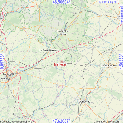
Melleray GPS coordinates[2]
48° 5' 54.96" North, 0° 48' 1.62" East
| Map corner | latitude | longitude |
|---|---|---|
| Upper-left | 48.56604°, | 0.09733° |
| Center: | 48.0986°, | 0.80045° |
| Lower-right: | 47.62687°, | 1.50358° |
| Map W x H: | 104.4×104.4 km | = 64.9×64.9mi |
| max Lat: | 51.07786° ⇑38.9% North |
| Melleray: | 48.0986° |
| min Lat: | ⇓61.1% South 41.3874° |
| min Long | Melleray | max Long |
| -5.08615° | 0.80045° | 9.52242° |
| W 29.5%⇐ | ⇒70.5% E |
Elevation
Elevation of Melleray is 163 m = 535 ft, and this is 30.7 m = 101 ft below average elevation for this country.
| Max E: |
2333 m = 7654 ft | 41.6% |
| Avg. | 193.7 m = 635 ft | |
| Melleray | 163 m = 535 ft | |
Min E: |
-1 m = -3 ft | 58.4% |
See also: France elevation on elevation.city.
Geographical zone
Melleray is located in North temperate zone (between Tropic of Cancer and the Arctic Circle). Distance of this North polar circle is 2053.1 km =1275.7 mi to North.| Distance of | km | miles | from Melleray |
|---|---|---|---|
| North Pole | 4659 | 2895 | to North |
| Arctic Circle | 2053.1 | 1275.7 | to North |
| Tropic Cancer | 2742.1 | 1703.9 | to South |
| Equator | 5348.1 | 3323.2 | to South |


Nearby cities:
15 places around Melleray: (largest is in red/bold)
• Authon-du-Perche
12.8 km =8 mi,  32°
32°
• Ceton
14.7 km =9.1 mi,  345°
345°
• Cherreau
13.6 km =8.5 mi,  320°
320°
• Cherré
13.4 km =8.3 mi,  307°
307°
• Choue
14.8 km =9.2 mi,  137°
137°
• Cormenon
16 km =9.9 mi,  154°
154°
• Cormes
10.5 km =6.5 mi, 317°
• La Bazoche-Gouet
14.2 km =8.8 mi,  71°
71°
• La Ferté-Bernard
14.6 km =9.1 mi, 311°
• Lamnay
7.3 km =4.5 mi,  286°
286°
• Lavaré
12.6 km =7.8 mi,  246°
246°
• Mondoubleau
15 km =9.3 mi, 151°
• Saint-Maixent
11 km =6.8 mi,  264°
264°
• Souday
8.5 km =5.3 mi, 144°
• Vibraye
6.4 km =4 mi,  222°
222°
Sources, notices
• [Note1] Compared only with cities in France existing in our database
• [Src1] Map data: © OpenStreetMap contributors (CC-BY-SA)
• [Src2] Other city data from geonames.org with taken over terms of usage.
• [Src3] Geographical zone / Annual Mean Temperature by Robert A. Rohde @ Wikipedia
