Vibraye geodata
Vibraye (Pays de la Loire) is a populated place; located in France in Europe/Paris (GMT+2) time zone. With population of 2,707 people, there are 3611 cities with bigger population in this country. Compared to other cities in France, 60.3% of cities are located further ↓South; 71.1% of cities are located further →East and 52.3% of cities have higher elevation than Vibraye. Note1
Administrative division(s):
- Level 1: Pays de la Loire
- Level 2: Sarthe
- Level 3: Arrondissement de Mamers
- Level 4: Vibraye


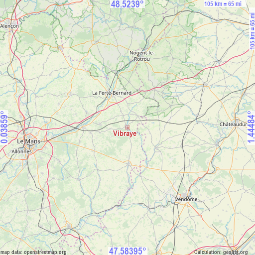
Vibraye GPS coordinates[2]
48° 3' 21.852" North, 0° 44' 30.156" East
| Map corner | latitude | longitude |
|---|---|---|
| Upper-left | 48.5239°, | 0.03859° |
| Center: | 48.05607°, | 0.74171° |
| Lower-right: | 47.58395°, | 1.44484° |
| Map W x H: | 104.5×104.5 km | = 64.9×64.9mi |
| max Lat: | 51.07786° ⇑39.7% North |
| Vibraye: | 48.05607° |
| min Lat: | ⇓60.3% South 41.3874° |
| min Long | Vibraye | max Long |
| -5.08615° | 0.74171° | 9.52242° |
| W 28.9%⇐ | ⇒71.1% E |
Elevation
Elevation of Vibraye is 124 m = 407 ft, and this is 69.7 m = 229 ft below average elevation for this country.
| Max E: |
2333 m = 7654 ft | 52.3% |
| Avg. | 193.7 m = 635 ft | |
| Vibraye | 124 m = 407 ft | |
Min E: |
-1 m = -3 ft | 47.7% |
See also: France elevation on elevation.city.
Geographical zone
Vibraye is located in North temperate zone (between Tropic of Cancer and the Arctic Circle). Distance of this North polar circle is 2057.8 km =1278.7 mi to North.| Distance of | km | miles | from Vibraye |
|---|---|---|---|
| North Pole | 4663.7 | 2897.9 | to North |
| Arctic Circle | 2057.8 | 1278.7 | to North |
| Tropic Cancer | 2737.4 | 1700.9 | to South |
| Equator | 5343.3 | 3320.2 | to South |


Nearby cities:
15 places around Vibraye: (largest is in red/bold)
• Cherré
14.4 km =8.9 mi,  334°
334°
• Conflans-sur-Anille
12.3 km =7.6 mi,  178°
178°
• Cormes
12.9 km =8 mi,  347°
347°
• Coudrecieux
10.9 km =6.8 mi,  230°
230°
• Dollon
11.7 km =7.3 mi,  260°
260°
• Lamnay
7.3 km =4.5 mi,  339°
339°
• Lavaré
7.2 km =4.5 mi,  267°
267°
• Le Luart
11.7 km =7.3 mi,  277°
277°
• Melleray
6.4 km =4 mi,  42°
42°
• Mondoubleau
14.3 km =8.9 mi,  125°
125°
• Montaillé
13.6 km =8.5 mi,  192°
192°
• Saint-Maixent
7.5 km =4.7 mi,  299°
299°
• Saint-Michel-de-Chavaignes
13.3 km =8.3 mi,  251°
251°
• Sceaux-sur-Huisne
12.9 km =8 mi,  294°
294°
• Souday
9.5 km =5.9 mi,  102°
102°
Sources, notices
• [Note1] Compared only with cities in France existing in our database
• [Src1] Map data: © OpenStreetMap contributors (CC-BY-SA)
• [Src2] Other city data from geonames.org with taken over terms of usage.
• [Src3] Geographical zone / Annual Mean Temperature by Robert A. Rohde @ Wikipedia
