Conty geodata
Conty (Hauts-de-France) is a populated place; located in France in Europe/Paris (GMT+2) time zone. With population of 1,727 people, there are 5454 cities with bigger population in this country. Compared to other cities in France, 91.9% of cities are located further ↓South; 55.1% of cities are located further →East and 76.6% of cities have higher elevation than Conty. Note1


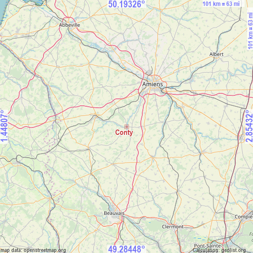
Conty GPS coordinates[2]
49° 44' 27.6" North, 2° 9' 4.32" East
| Map corner | latitude | longitude |
|---|---|---|
| Upper-left | 50.19326°, | 1.44807° |
| Center: | 49.741°, | 2.1512° |
| Lower-right: | 49.28448°, | 2.85432° |
| Map W x H: | 101×101 km | = 62.8×62.8mi |
| max Lat: | 51.07786° ⇑8.1% North |
| Conty: | 49.741° |
| min Lat: | ⇓91.9% South 41.3874° |
| min Long | Conty | max Long |
| -5.08615° | 2.1512° | 9.52242° |
| W 44.9%⇐ | ⇒55.1% E |
Elevation
Elevation of Conty is 63 m = 207 ft, and this is 130.7 m = 429 ft below average elevation for this country.
| Max E: |
2333 m = 7654 ft | 76.6% |
| Avg. | 193.7 m = 635 ft | |
| Conty | 63 m = 207 ft | |
Min E: |
-1 m = -3 ft | 23.4% |
See also: France elevation on elevation.city.
Geographical zone
Conty is located in North temperate zone (between Tropic of Cancer and the Arctic Circle). Distance of this North polar circle is 1870.5 km =1162.3 mi to North.| Distance of | km | miles | from Conty |
|---|---|---|---|
| North Pole | 4476.4 | 2781.5 | to North |
| Arctic Circle | 1870.5 | 1162.3 | to North |
| Tropic Cancer | 2924.8 | 1817.4 | to South |
| Equator | 5530.7 | 3436.6 | to South |


Nearby cities:
15 places around Conty: (largest is in red/bold)
• Bacouel-sur-Selle
11.2 km =7 mi,  28°
28°
• Bonneuil-les-Eaux
9.3 km =5.8 mi,  138°
138°
• Chaussoy-Epagny
13.1 km =8.1 mi,  93°
93°
• Esquennoy
12.5 km =7.8 mi, 137°
• Lœuilly
4.8 km =3 mi,  13°
13°
• Oresmaux
9.1 km =5.7 mi,  70°
70°
• Plachy-Buyon
9.5 km =5.9 mi, 30°
• Poix-de-Picardie
12.9 km =8 mi,  291°
291°
• Prouzel
9.3 km =5.8 mi,  23°
23°
• Quevauvillers
10.4 km =6.5 mi,  332°
332°
• Revelles
12.2 km =7.6 mi,  350°
350°
• Rumigny
11.9 km =7.4 mi,  51°
51°
• Saint-Sauflieu
9.1 km =5.7 mi, 53°
• Saleux
14.2 km =8.8 mi, 25°
• Vers-sur-Selles
11.8 km =7.3 mi, 29°
Sources, notices
• [Note1] Compared only with cities in France existing in our database
• [Src1] Map data: © OpenStreetMap contributors (CC-BY-SA)
• [Src2] Other city data from geonames.org with taken over terms of usage.
• [Src3] Geographical zone / Annual Mean Temperature by Robert A. Rohde @ Wikipedia
