Quevauvillers geodata
Quevauvillers (Hauts-de-France) is a populated place; located in France in Europe/Paris (GMT+2) time zone. With population of 1,036 people, there are 8567 cities with bigger population in this country. Compared to other cities in France, 92.4% of cities are located further ↓South; 56% of cities are located further →East and 50.8% of cities have lower elevation than Quevauvillers. Note1
Administrative division(s):
- Level 1: Hauts-de-France
- Level 2: Somme
- Level 3: Amiens
- Level 4: Quevauvillers


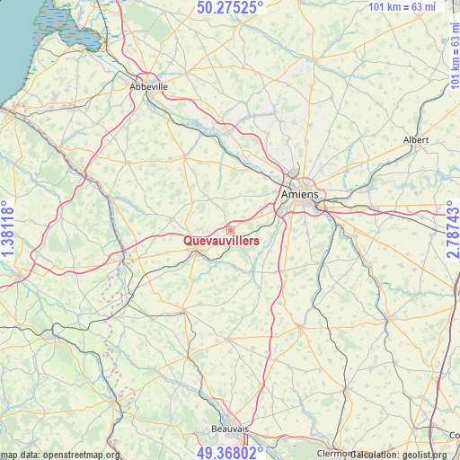
Quevauvillers GPS coordinates[2]
49° 49' 25.536" North, 2° 5' 3.516" East
| Map corner | latitude | longitude |
|---|---|---|
| Upper-left | 50.27525°, | 1.38118° |
| Center: | 49.82376°, | 2.08431° |
| Lower-right: | 49.36802°, | 2.78743° |
| Map W x H: | 100.9×100.9 km | = 62.7×62.7mi |
| max Lat: | 51.07786° ⇑7.6% North |
| Quevauvillers: | 49.82376° |
| min Lat: | ⇓92.4% South 41.3874° |
| min Long | Quevauvillers | max Long |
| -5.08615° | 2.08431° | 9.52242° |
| W 44%⇐ | ⇒56% E |
Elevation
Elevation of Quevauvillers is 135 m = 443 ft, and this is 58.7 m = 193 ft below average elevation for this country.
| Max E: |
2333 m = 7654 ft | 49.2% |
| Avg. | 193.7 m = 635 ft | |
| Quevauvillers | 135 m = 443 ft | |
Min E: |
-1 m = -3 ft | 50.8% |
See also: France elevation on elevation.city.
Geographical zone
Quevauvillers is located in North temperate zone (between Tropic of Cancer and the Arctic Circle). Distance of this North polar circle is 1861.3 km =1156.6 mi to North.| Distance of | km | miles | from Quevauvillers |
|---|---|---|---|
| North Pole | 4467.2 | 2775.8 | to North |
| Arctic Circle | 1861.3 | 1156.6 | to North |
| Tropic Cancer | 2934 | 1823.1 | to South |
| Equator | 5539.9 | 3442.3 | to South |


Nearby cities:
15 places around Quevauvillers: (largest is in red/bold)
• Bacouel-sur-Selle
10.1 km =6.3 mi,  86°
86°
• Conty
10.4 km =6.5 mi,  152°
152°
• Hornoy-le-Bourg
13.5 km =8.4 mi,  282°
282°
• Lœuilly
7.4 km =4.6 mi,  127°
127°
• Molliens-Dreuil
8.2 km =5.1 mi,  323°
323°
• Plachy-Buyon
9.6 km =6 mi,  96°
96°
• Poix-de-Picardie
8.5 km =5.3 mi,  238°
238°
• Pont-de-Metz
12.9 km =8 mi,  61°
61°
• Prouzel
8.4 km =5.2 mi, 94°
• Revelles
3.9 km =2.4 mi,  43°
43°
• Saint-Sauflieu
12.7 km =7.9 mi,  107°
107°
• Saleux
11.5 km =7.1 mi,  71°
71°
• Salouël
12.5 km =7.8 mi, 65°
• Saveuse
12.8 km =8 mi,  48°
48°
• Vers-sur-Selles
10.7 km =6.6 mi,  84°
84°
Sources, notices
• [Note1] Compared only with cities in France existing in our database
• [Src1] Map data: © OpenStreetMap contributors (CC-BY-SA)
• [Src2] Other city data from geonames.org with taken over terms of usage.
• [Src3] Geographical zone / Annual Mean Temperature by Robert A. Rohde @ Wikipedia
