Revelles geodata
Revelles (Hauts-de-France) is a populated place; located in France in Europe/Paris (GMT+2) time zone. With population of 514 people, there are 14947 cities with bigger population in this country. Compared to other cities in France, 92.6% of cities are located further ↓South; 55.5% of cities are located further →East and 53.3% of cities have higher elevation than Revelles. Note1
Administrative division(s):
- Level 1: Hauts-de-France
- Level 2: Somme
- Level 3: Amiens
- Level 4: Revelles


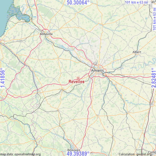
Revelles GPS coordinates[2]
49° 50' 57.804" North, 2° 7' 18.048" East
| Map corner | latitude | longitude |
|---|---|---|
| Upper-left | 50.30064°, | 1.41856° |
| Center: | 49.84939°, | 2.12168° |
| Lower-right: | 49.39389°, | 2.82481° |
| Map W x H: | 100.8×100.8 km | = 62.6×62.6mi |
| max Lat: | 51.07786° ⇑7.4% North |
| Revelles: | 49.84939° |
| min Lat: | ⇓92.6% South 41.3874° |
| min Long | Revelles | max Long |
| -5.08615° | 2.12168° | 9.52242° |
| W 44.5%⇐ | ⇒55.5% E |
Elevation
Elevation of Revelles is 121 m = 397 ft, and this is 72.7 m = 239 ft below average elevation for this country.
| Max E: |
2333 m = 7654 ft | 53.3% |
| Avg. | 193.7 m = 635 ft | |
| Revelles | 121 m = 397 ft | |
Min E: |
-1 m = -3 ft | 46.7% |
See also: France elevation on elevation.city.
Geographical zone
Revelles is located in North temperate zone (between Tropic of Cancer and the Arctic Circle). Distance of this North polar circle is 1858.4 km =1154.8 mi to North.| Distance of | km | miles | from Revelles |
|---|---|---|---|
| North Pole | 4464.3 | 2774 | to North |
| Arctic Circle | 1858.4 | 1154.8 | to North |
| Tropic Cancer | 2936.8 | 1824.8 | to South |
| Equator | 5542.7 | 3444.1 | to South |


Nearby cities:
15 places around Revelles: (largest is in red/bold)
• Ailly-sur-Somme
10.3 km =6.4 mi,  31°
31°
• Bacouel-sur-Selle
7.7 km =4.8 mi,  106°
106°
• Dreuil-lès-Amiens
10.6 km =6.6 mi,  46°
46°
• Dury
10.7 km =6.6 mi,  91°
91°
• Lœuilly
8 km =5 mi,  156°
156°
• Molliens-Dreuil
8.4 km =5.2 mi,  296°
296°
• Picquigny
10.7 km =6.6 mi,  8°
8°
• Plachy-Buyon
7.9 km =4.9 mi,  119°
119°
• Pont-de-Metz
9.2 km =5.7 mi,  69°
69°
• Prouzel
6.7 km =4.2 mi, 121°
• Quevauvillers
3.9 km =2.4 mi,  223°
223°
• Saleux
8.3 km =5.2 mi,  84°
84°
• Salouël
9 km =5.6 mi, 75°
• Saveuse
8.9 km =5.5 mi, 50°
• Vers-sur-Selles
8.2 km =5.1 mi,  102°
102°
Sources, notices
• [Note1] Compared only with cities in France existing in our database
• [Src1] Map data: © OpenStreetMap contributors (CC-BY-SA)
• [Src2] Other city data from geonames.org with taken over terms of usage.
• [Src3] Geographical zone / Annual Mean Temperature by Robert A. Rohde @ Wikipedia
