Saint-Geniès geodata
Saint-Geniès (Nouvelle-Aquitaine) is a populated place; located in France in Europe/Paris (GMT+2) time zone. With population of 993 people, there are 8879 cities with bigger population in this country. Compared to other cities in France, 79.6% of cities are located further ↑North; 66.1% of cities are located further →East and 67.6% of cities have lower elevation than Saint-Geniès. Note1
Administrative division(s):
- Level 1: Nouvelle-Aquitaine
- Level 2: Dordogne
- Level 3: Arrondissement de Sarlat-la-Canéda
- Level 4: Saint-Geniès


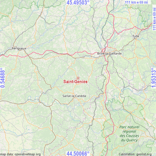
Saint-Geniès GPS coordinates[2]
45° 0' 0" North, 1° 15' 0" East
| Map corner | latitude | longitude |
|---|---|---|
| Upper-left | 45.49503°, | 0.54688° |
| Center: | 45°, | 1.25° |
| Lower-right: | 44.50066°, | 1.95313° |
| Map W x H: | 110.6×110.6 km | = 68.7×68.7mi |
| max Lat: | 51.07786° ⇑79.6% North |
| Saint-Geniès: | 45° |
| min Lat: | ⇓20.4% South 41.3874° |
| min Long | Saint-Geniès | max Long |
| -5.08615° | 1.25° | 9.52242° |
| W 33.9%⇐ | ⇒66.1% E |
Elevation
Elevation of Saint-Geniès is 207 m = 679 ft, and this is 13.3 m = 44 ft above average elevation for this country.
| Max E: |
2333 m = 7654 ft | 32.4% |
| Saint-Geniès | 207 m 679 ft | |
| Avg. | 193.7 m = 635 ft | |
Min E: |
-1 m = -3 ft | 67.6% |
See also: France elevation on elevation.city.
Geographical zone
Saint-Geniès is located in North temperate zone (between Tropic of Cancer and the Arctic Circle). Distance of this Northern Tropic circle is 2397.6 km =1489.8 mi to South.| Distance of | km | miles | from Saint-Geniès |
|---|---|---|---|
| North Pole | 5003.5 | 3109 | to North |
| Arctic Circle | 2397.6 | 1489.8 | to North |
| Tropic Cancer | 2397.6 | 1489.8 | to South |
| Equator | 5003.5 | 3109 | to South |


Nearby cities:
15 places around Saint-Geniès: (largest is in red/bold)
• Aubas
10.2 km =6.3 mi,  333°
333°
• Beauregard-de-Terrasson
16.6 km =10.3 mi,  354°
354°
• Carlux
15.2 km =9.4 mi,  148°
148°
• Condat-sur-Vézère
13.2 km =8.2 mi, 353°
• Cublac
16.7 km =10.4 mi,  15°
15°
• Eyvigues-et-Eybènes
10.8 km =6.7 mi,  133°
133°
• Gignac
16.3 km =10.1 mi,  87°
87°
• Le Lardin-Saint-Lazare
15.1 km =9.4 mi, 349°
• Marcillac-Saint-Quentin
3.9 km =2.4 mi,  199°
199°
• Marquay
9.6 km =6 mi,  234°
234°
• Montignac
9.9 km =6.2 mi,  315°
315°
• Proissans
7.5 km =4.7 mi,  190°
190°
• Salignac-Eyvigues
6.5 km =4 mi,  115°
115°
• Sarlat-la-Canéda
12.6 km =7.8 mi, 192°
• Terrasson-Lavilledieu
15 km =9.3 mi, 15°
Sources, notices
• [Note1] Compared only with cities in France existing in our database
• [Src1] Map data: © OpenStreetMap contributors (CC-BY-SA)
• [Src2] Other city data from geonames.org with taken over terms of usage.
• [Src3] Geographical zone / Annual Mean Temperature by Robert A. Rohde @ Wikipedia
