Colombier-le-Jeune geodata
Colombier-le-Jeune (Auvergne-Rhône-Alpes) is a populated place; located in France in Europe/Paris (GMT+2) time zone. With population of 535 people, there are 14511 cities with bigger population in this country. Compared to other cities in France, 79.5% of cities are located further ↑North; 73.8% of cities are located further ←West and 93.3% of cities have lower elevation than Colombier-le-Jeune. Note1
Administrative division(s):
- Level 1: Auvergne-Rhône-Alpes
- Level 2: Département de l'Ardèche
- Level 3: Arrondissement de Tournon-sur-Rhône
- Level 4: Colombier-le-Jeune


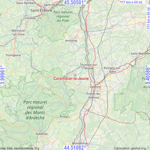
Colombier-le-Jeune GPS coordinates[2]
45° 0' 36.252" North, 4° 42' 9.828" East
| Map corner | latitude | longitude |
|---|---|---|
| Upper-left | 45.50501°, | 3.99961° |
| Center: | 45.01007°, | 4.70273° |
| Lower-right: | 44.51082°, | 5.40586° |
| Map W x H: | 110.5×110.5 km | = 68.7×68.7mi |
| max Lat: | 51.07786° ⇑79.5% North |
| Colombier-le-Jeune: | 45.01007° |
| min Lat: | ⇓20.5% South 41.3874° |
| min Long | Colombier-le-Je | max Long |
| -5.08615° | 4.70273° | 9.52242° |
| W 73.8%⇐ | ⇒26.2% E |
Elevation
Elevation of Colombier-le-Jeune is 515 m = 1690 ft, and this is 321.3 m = 1054 ft above average elevation for this country.
| Max E: |
2333 m = 7654 ft | 6.7% |
| Colombier-le-Jeune | 515 m 1690 ft | |
| Avg. | 193.7 m = 635 ft | |
Min E: |
-1 m = -3 ft | 93.3% |
See also: France elevation on elevation.city.
Geographical zone
Colombier-le-Jeune is located in North temperate zone (between Tropic of Cancer and the Arctic Circle). Distance of this North polar circle is 2396.5 km =1489.1 mi to North.| Distance of | km | miles | from Colombier-le-Jeune |
|---|---|---|---|
| North Pole | 5002.4 | 3108.3 | to North |
| Arctic Circle | 2396.5 | 1489.1 | to North |
| Tropic Cancer | 2398.7 | 1490.5 | to South |
| Equator | 5004.7 | 3109.8 | to South |


Nearby cities:
15 places around Colombier-le-Jeune: (largest is in red/bold)
• Alboussière
7.6 km =4.7 mi,  164°
164°
• Boffres
9.9 km =6.2 mi,  179°
179°
• Colombier-le-Vieux
6.2 km =3.9 mi,  355°
355°
• Empurany
7.6 km =4.7 mi,  282°
282°
• Glun
10.7 km =6.6 mi,  86°
86°
• La Roche-de-Glun
11.2 km =7 mi, 88°
• Lamastre
10 km =6.2 mi,  254°
254°
• Le Crestet
3.8 km =2.4 mi, 277°
• Mauves
10.4 km =6.5 mi,  72°
72°
• Plats
6.2 km =3.9 mi, 90°
• Saint-Barthélemy-le-Plain
6 km =3.7 mi,  35°
35°
• Saint-Félicien
10.3 km =6.4 mi,  324°
324°
• Saint-Romain-de-Lerps
8.2 km =5.1 mi,  115°
115°
• Saint-Victor
10.4 km =6.5 mi,  346°
346°
• Étables
10.3 km =6.4 mi,  9°
9°
Sources, notices
• [Note1] Compared only with cities in France existing in our database
• [Src1] Map data: © OpenStreetMap contributors (CC-BY-SA)
• [Src2] Other city data from geonames.org with taken over terms of usage.
• [Src3] Geographical zone / Annual Mean Temperature by Robert A. Rohde @ Wikipedia
