Boffres geodata
Boffres (Auvergne-Rhône-Alpes) is a populated place; located in France in Europe/Paris (GMT+2) time zone. With population of 535 people, there are 14511 cities with bigger population in this country. Compared to other cities in France, 80.3% of cities are located further ↑North; 73.8% of cities are located further ←West and 95% of cities have lower elevation than Boffres. Note1
Administrative division(s):
- Level 1: Auvergne-Rhône-Alpes
- Level 2: Département de l'Ardèche
- Level 3: Arrondissement de Tournon-sur-Rhône
- Level 4: Boffres


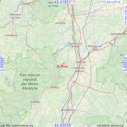
Boffres GPS coordinates[2]
44° 55' 14.124" North, 4° 42' 10.8" East
| Map corner | latitude | longitude |
|---|---|---|
| Upper-left | 45.41631°, | 3.99988° |
| Center: | 44.92059°, | 4.703° |
| Lower-right: | 44.42056°, | 5.40613° |
| Map W x H: | 110.7×110.7 km | = 68.8×68.8mi |
| max Lat: | 51.07786° ⇑80.3% North |
| Boffres: | 44.92059° |
| min Lat: | ⇓19.7% South 41.3874° |
| min Long | Boffres | max Long |
| -5.08615° | 4.703° | 9.52242° |
| W 73.8%⇐ | ⇒26.2% E |
Elevation
Elevation of Boffres is 583 m = 1913 ft, and this is 389.3 m = 1277 ft above average elevation for this country.
| Max E: |
2333 m = 7654 ft | 5% |
| Boffres | 583 m 1913 ft | |
| Avg. | 193.7 m = 635 ft | |
Min E: |
-1 m = -3 ft | 95% |
See also: France elevation on elevation.city.
Geographical zone
Boffres is located in North temperate zone (between Tropic of Cancer and the Arctic Circle). Distance of this Northern Tropic circle is 2388.8 km =1484.3 mi to South.| Distance of | km | miles | from Boffres |
|---|---|---|---|
| North Pole | 5012.4 | 3114.6 | to North |
| Arctic Circle | 2406.5 | 1495.3 | to North |
| Tropic Cancer | 2388.8 | 1484.3 | to South |
| Equator | 4994.7 | 3103.6 | to South |


Nearby cities:
15 places around Boffres: (largest is in red/bold)
• Alboussière
3.3 km =2.1 mi,  37°
37°
• Charmes-sur-Rhône
12.2 km =7.6 mi,  121°
121°
• Colombier-le-Jeune
9.9 km =6.2 mi,  359°
359°
• Cornas
12.4 km =7.7 mi,  67°
67°
• Lamastre
12.2 km =7.6 mi,  307°
307°
• Le Crestet
11.1 km =6.9 mi,  340°
340°
• Plats
11.7 km =7.3 mi,  32°
32°
• Saint-Fortunat-sur-Eyrieux
10.3 km =6.4 mi,  191°
191°
• Saint-Georges-les-Bains
10.7 km =6.6 mi,  128°
128°
• Saint-Laurent-du-Pape
11.9 km =7.4 mi,  155°
155°
• Saint-Péray
11.6 km =7.2 mi, 74°
• Saint-Romain-de-Lerps
9.8 km =6.1 mi,  48°
48°
• Soyons
12.1 km =7.5 mi,  106°
106°
• Toulaud
9.3 km =5.8 mi, 105°
• Vernoux-en-Vivarais
5.3 km =3.3 mi,  238°
238°
Sources, notices
• [Note1] Compared only with cities in France existing in our database
• [Src1] Map data: © OpenStreetMap contributors (CC-BY-SA)
• [Src2] Other city data from geonames.org with taken over terms of usage.
• [Src3] Geographical zone / Annual Mean Temperature by Robert A. Rohde @ Wikipedia
