Glun geodata
Glun (Auvergne-Rhône-Alpes) is a populated place; located in France in Europe/Paris (GMT+2) time zone. With population of 639 people, there are 12686 cities with bigger population in this country. Compared to other cities in France, 79.5% of cities are located further ↑North; 75.6% of cities are located further ←West and 54.8% of cities have higher elevation than Glun. Note1
Administrative division(s):
- Level 1: Auvergne-Rhône-Alpes
- Level 2: Département de l'Ardèche
- Level 3: Arrondissement de Tournon-sur-Rhône
- Level 4: Glun


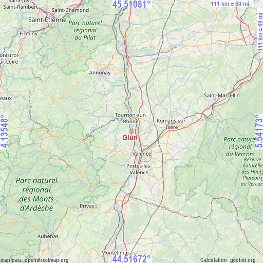
Glun GPS coordinates[2]
45° 0' 57.312" North, 4° 50' 18.996" East
| Map corner | latitude | longitude |
|---|---|---|
| Upper-left | 45.51081°, | 4.13548° |
| Center: | 45.01592°, | 4.83861° |
| Lower-right: | 44.51672°, | 5.54173° |
| Map W x H: | 110.5×110.5 km | = 68.7×68.7mi |
| max Lat: | 51.07786° ⇑79.5% North |
| Glun: | 45.01592° |
| min Lat: | ⇓20.5% South 41.3874° |
| min Long | Glun | max Long |
| -5.08615° | 4.83861° | 9.52242° |
| W 75.6%⇐ | ⇒24.4% E |
Elevation
Elevation of Glun is 117 m = 384 ft, and this is 76.7 m = 252 ft below average elevation for this country.
| Max E: |
2333 m = 7654 ft | 54.8% |
| Avg. | 193.7 m = 635 ft | |
| Glun | 117 m = 384 ft | |
Min E: |
-1 m = -3 ft | 45.2% |
See also: France elevation on elevation.city.
Geographical zone
Glun is located in North temperate zone (between Tropic of Cancer and the Arctic Circle). Distance of this North polar circle is 2395.9 km =1488.7 mi to North.| Distance of | km | miles | from Glun |
|---|---|---|---|
| North Pole | 5001.8 | 3108 | to North |
| Arctic Circle | 2395.9 | 1488.7 | to North |
| Tropic Cancer | 2399.4 | 1490.9 | to South |
| Equator | 5005.3 | 3110.1 | to South |


Nearby cities:
15 places around Glun: (largest is in red/bold)
• Beaumont-Monteux
6.3 km =3.9 mi,  86°
86°
• Bourg-lès-Valence
8.8 km =5.5 mi,  150°
150°
• Chanos-Curson
8.3 km =5.2 mi,  53°
53°
• Châteauneuf-sur-Isère
7.4 km =4.6 mi, 89°
• Cornas
5.8 km =3.6 mi,  172°
172°
• La Roche-de-Glun
0.6 km =0.4 mi,  120°
120°
• Mauves
2.6 km =1.6 mi,  343°
343°
• Mercurol-Veaunes
7.8 km =4.8 mi,  33°
33°
• Plats
4.5 km =2.8 mi,  261°
261°
• Saint-Barthélemy-le-Plain
8.4 km =5.2 mi,  300°
300°
• Saint-Jean-de-Muzols
7.6 km =4.7 mi,  345°
345°
• Saint-Péray
7.5 km =4.7 mi,  176°
176°
• Saint-Romain-de-Lerps
5.3 km =3.3 mi,  218°
218°
• Tain-l’Hermitage
5.8 km =3.6 mi,  13°
13°
• Tournon-sur-Rhône
5.7 km =3.5 mi,  355°
355°
Sources, notices
• [Note1] Compared only with cities in France existing in our database
• [Src1] Map data: © OpenStreetMap contributors (CC-BY-SA)
• [Src2] Other city data from geonames.org with taken over terms of usage.
• [Src3] Geographical zone / Annual Mean Temperature by Robert A. Rohde @ Wikipedia
