Saint-Romain-de-Lerps geodata
Saint-Romain-de-Lerps (Auvergne-Rhône-Alpes) is a populated place; located in France in Europe/Paris (GMT+2) time zone. With population of 576 people, there are 13727 cities with bigger population in this country. Compared to other cities in France, 79.8% of cities are located further ↑North; 75% of cities are located further ←West and 93.9% of cities have lower elevation than Saint-Romain-de-Lerps. Note1
Administrative division(s):
- Level 1: Auvergne-Rhône-Alpes
- Level 2: Département de l'Ardèche
- Level 3: Arrondissement de Tournon-sur-Rhône
- Level 4: Saint-Romain-de-Lerps
Current local time in Saint-Romain-de-Lerps:
05:55 AM, WednesdayDifference from your time zone: hours


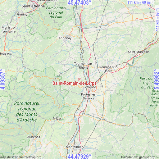
Saint-Romain-de-Lerps GPS coordinates[2]
44° 58' 43.752" North, 4° 47' 48.12" East
| Map corner | latitude | longitude |
|---|---|---|
| Upper-left | 45.47403°, | 4.09357° |
| Center: | 44.97882°, | 4.7967° |
| Lower-right: | 44.47929°, | 5.49982° |
| Map W x H: | 110.6×110.6 km | = 68.7×68.7mi |
| max Lat: | 51.07786° ⇑79.8% North |
| Saint-Romain-de-Lerps: | 44.97882° |
| min Lat: | ⇓20.2% South 41.3874° |
| min Long | Saint-Romain-de | max Long |
| -5.08615° | 4.7967° | 9.52242° |
| W 75%⇐ | ⇒25% E |
Elevation
Elevation of Saint-Romain-de-Lerps is 539 m = 1768 ft, and this is 345.3 m = 1133 ft above average elevation for this country.
| Max E: |
2333 m = 7654 ft | 6.1% |
| Saint-Romain-de-Lerps | 539 m 1768 ft | |
| Avg. | 193.7 m = 635 ft | |
Min E: |
-1 m = -3 ft | 93.9% |
See also: France elevation on elevation.city.
Geographical zone
Saint-Romain-de-Lerps is located in North temperate zone (between Tropic of Cancer and the Arctic Circle). Distance of this Northern Tropic circle is 2395.3 km =1488.4 mi to South.| Distance of | km | miles | from Saint-Romain-de-Lerps |
|---|---|---|---|
| North Pole | 5005.9 | 3110.5 | to North |
| Arctic Circle | 2400 | 1491.3 | to North |
| Tropic Cancer | 2395.3 | 1488.4 | to South |
| Equator | 5001.2 | 3107.6 | to South |


Nearby cities:
15 places around Saint-Romain-de-Lerps: (largest is in red/bold)
• Alboussière
6.6 km =4.1 mi,  234°
234°
• Beaumont-Monteux
10.6 km =6.6 mi,  64°
64°
• Boffres
9.8 km =6.1 mi, 228°
• Bourg-lès-Valence
8.5 km =5.3 mi,  114°
114°
• Colombier-le-Jeune
8.2 km =5.1 mi,  295°
295°
• Cornas
4.4 km =2.7 mi, 112°
• Glun
5.3 km =3.3 mi,  38°
38°
• Guilherand-Granges
7.9 km =4.9 mi,  130°
130°
• La Roche-de-Glun
5.4 km =3.4 mi, 44°
• Mauves
7.1 km =4.4 mi,  21°
21°
• Plats
3.6 km =2.2 mi,  341°
341°
• Saint-Barthélemy-le-Plain
9.3 km =5.8 mi,  334°
334°
• Saint-Péray
5.1 km =3.2 mi, 131°
• Toulaud
9.1 km =5.7 mi,  170°
170°
• Tournon-sur-Rhône
10.2 km =6.3 mi, 16°
Sources, notices
• [Note1] Compared only with cities in France existing in our database
• [Src1] Map data: © OpenStreetMap contributors (CC-BY-SA)
• [Src2] Other city data from geonames.org with taken over terms of usage.
• [Src3] Geographical zone / Annual Mean Temperature by Robert A. Rohde @ Wikipedia
