Saint-Sulpice-de-Cognac geodata
Saint-Sulpice-de-Cognac (Nouvelle-Aquitaine) is a populated place; located in France in Europe/Paris (GMT+2) time zone. With population of 1,226 people, there are 7407 cities with bigger population in this country. Compared to other cities in France, 69.9% of cities are located further ↑North; 81.8% of cities are located further →East and 95.7% of cities have higher elevation than Saint-Sulpice-de-Cognac. Note1
Administrative division(s):
- Level 1: Nouvelle-Aquitaine
- Level 2: Charente
- Level 3: Arrondissement de Cognac
- Level 4: Saint-Sulpice-de-Cognac
Current local time in Saint-Sulpice-de-Cognac:
03:34 PM, SaturdayDifference from your time zone: hours


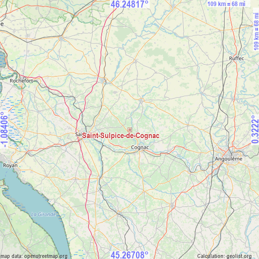
Saint-Sulpice-de-Cognac GPS coordinates[2]
45° 45' 35.208" North, 0° 22' 51.348" West
| Map corner | latitude | longitude |
|---|---|---|
| Upper-left | 46.24817°, | -1.08406° |
| Center: | 45.75978°, | -0.38093° |
| Lower-right: | 45.26708°, | 0.3222° |
| Map W x H: | 109.1×109.1 km | = 67.8×67.8mi |
| max Lat: | 51.07786° ⇑69.9% North |
| Saint-Sulpice-de-Cognac: | 45.75978° |
| min Lat: | ⇓30.1% South 41.3874° |
| min Long | Saint-Sulpice-d | max Long |
| -5.08615° | -0.38093° | 9.52242° |
| W 18.2%⇐ | ⇒81.8% E |
Elevation
Elevation of Saint-Sulpice-de-Cognac is 15 m = 49 ft, and this is 178.7 m = 586 ft below average elevation for this country.
| Max E: |
2333 m = 7654 ft | 95.7% |
| Avg. | 193.7 m = 635 ft | |
| Saint-Sulpice-de-Cognac | 15 m = 49 ft | |
Min E: |
-1 m = -3 ft | 4.3% |
See also: France elevation on elevation.city.
Geographical zone
Saint-Sulpice-de-Cognac is located in North temperate zone (between Tropic of Cancer and the Arctic Circle). Distance of this North polar circle is 2313.2 km =1437.4 mi to North.| Distance of | km | miles | from Saint-Sulpice-de-Cognac |
|---|---|---|---|
| North Pole | 4919.1 | 3056.6 | to North |
| Arctic Circle | 2313.2 | 1437.4 | to North |
| Tropic Cancer | 2482.1 | 1542.3 | to South |
| Equator | 5088 | 3161.5 | to South |


Nearby cities:
15 places around Saint-Sulpice-de-Cognac: (largest is in red/bold)
• Boutiers-Saint-Trojan
7.9 km =4.9 mi,  127°
127°
• Brizambourg
10.4 km =6.5 mi,  312°
312°
• Bréville
10.1 km =6.3 mi,  66°
66°
• Burie
3.6 km =2.2 mi,  293°
293°
• Cherves-Richemont
3 km =1.9 mi, 127°
• Châteaubernard
11 km =6.8 mi,  160°
160°
• Chérac
7.6 km =4.7 mi,  216°
216°
• Cognac
8.2 km =5.1 mi,  150°
150°
• Javrezac
7.1 km =4.4 mi, 160°
• Merpins
8.6 km =5.3 mi,  189°
189°
• Migron
4.9 km =3 mi,  346°
346°
• Saint-Laurent-de-Cognac
7.3 km =4.5 mi,  197°
197°
• Saint-Sauvant
9.9 km =6.2 mi,  256°
256°
• Sainte-Sévère
11.1 km =6.9 mi,  94°
94°
• Salignac-sur-Charente
10.5 km =6.5 mi, 201°
Sources, notices
• [Note1] Compared only with cities in France existing in our database
• [Src1] Map data: © OpenStreetMap contributors (CC-BY-SA)
• [Src2] Other city data from geonames.org with taken over terms of usage.
• [Src3] Geographical zone / Annual Mean Temperature by Robert A. Rohde @ Wikipedia
