Avy geodata
Avy (Nouvelle-Aquitaine) is a populated place; located in France in Europe/Paris (GMT+2) time zone. With population of 515 people, there are 14927 cities with bigger population in this country. Compared to other cities in France, 73.3% of cities are located further ↑North; 83.5% of cities are located further →East and 83.4% of cities have higher elevation than Avy. Note1
Administrative division(s):
- Level 1: Nouvelle-Aquitaine
- Level 2: Charente-Maritime
- Level 3: Arrondissement de Jonzac
- Level 4: Avy


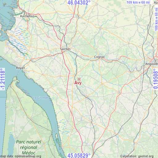
Avy GPS coordinates[2]
45° 33' 10.116" North, 0° 30' 28.98" West
| Map corner | latitude | longitude |
|---|---|---|
| Upper-left | 46.04302°, | -1.21118° |
| Center: | 45.55281°, | -0.50805° |
| Lower-right: | 45.05829°, | 0.19508° |
| Map W x H: | 109.5×109.5 km | = 68×68mi |
| max Lat: | 51.07786° ⇑73.3% North |
| Avy: | 45.55281° |
| min Lat: | ⇓26.7% South 41.3874° |
| min Long | Avy | max Long |
| -5.08615° | -0.50805° | 9.52242° |
| W 16.5%⇐ | ⇒83.5% E |
Elevation
Elevation of Avy is 46 m = 151 ft, and this is 147.7 m = 485 ft below average elevation for this country.
| Max E: |
2333 m = 7654 ft | 83.4% |
| Avg. | 193.7 m = 635 ft | |
| Avy | 46 m = 151 ft | |
Min E: |
-1 m = -3 ft | 16.6% |
See also: France elevation on elevation.city.
Geographical zone
Avy is located in North temperate zone (between Tropic of Cancer and the Arctic Circle). Distance of this North polar circle is 2336.2 km =1451.6 mi to North.| Distance of | km | miles | from Avy |
|---|---|---|---|
| North Pole | 4942.1 | 3070.9 | to North |
| Arctic Circle | 2336.2 | 1451.6 | to North |
| Tropic Cancer | 2459.1 | 1528 | to South |
| Equator | 5065 | 3147.2 | to South |


Nearby cities:
15 places around Avy: (largest is in red/bold)
• Ars
14.1 km =8.8 mi,  44°
44°
• Champagnolles
10.9 km =6.8 mi,  246°
246°
• Clion
8.2 km =5.1 mi,  176°
176°
• Germignac
13.7 km =8.5 mi,  83°
83°
• Gimeux
14.2 km =8.8 mi,  49°
49°
• Gémozac
13.2 km =8.2 mi,  277°
277°
• Jarnac-Champagne
8.4 km =5.2 mi,  85°
85°
• Jonzac
13.1 km =8.1 mi,  153°
153°
• Montils
10.6 km =6.6 mi,  2°
2°
• Pons
4.3 km =2.7 mi,  314°
314°
• Pérignac
8.5 km =5.3 mi,  23°
23°
• Réaux
13.4 km =8.3 mi,  128°
128°
• Saint-Genis-de-Saintonge
9.3 km =5.8 mi,  210°
210°
• Saint-Germain-de-Lusignan
12 km =7.5 mi,  162°
162°
• Saint-Léger
9.7 km =6 mi,  322°
322°
Sources, notices
• [Note1] Compared only with cities in France existing in our database
• [Src1] Map data: © OpenStreetMap contributors (CC-BY-SA)
• [Src2] Other city data from geonames.org with taken over terms of usage.
• [Src3] Geographical zone / Annual Mean Temperature by Robert A. Rohde @ Wikipedia
