Cires-lès-Mello geodata
Cires-lès-Mello (Hauts-de-France) is a populated place; located in France in Europe/Paris (GMT+2) time zone. With population of 3,539 people, there are 2748 cities with bigger population in this country. Compared to other cities in France, 85.5% of cities are located further ↓South; 51.7% of cities are located further →East and 87.1% of cities have higher elevation than Cires-lès-Mello. Note1
Administrative division(s):
- Level 1: Hauts-de-France
- Level 2: Département de l'Oise
- Level 3: Arrondissement de Senlis
- Level 4: Cires-lès-Mello


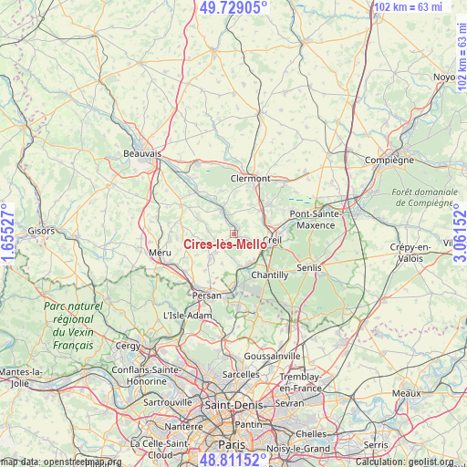
Cires-lès-Mello GPS coordinates[2]
49° 16' 20.712" North, 2° 21' 30.24" East
| Map corner | latitude | longitude |
|---|---|---|
| Upper-left | 49.72905°, | 1.65527° |
| Center: | 49.27242°, | 2.3584° |
| Lower-right: | 48.81152°, | 3.06152° |
| Map W x H: | 102×102 km | = 63.4×63.4mi |
| max Lat: | 51.07786° ⇑14.5% North |
| Cires-lès-Mello: | 49.27242° |
| min Lat: | ⇓85.5% South 41.3874° |
| min Long | Cires-lès-Mell | max Long |
| -5.08615° | 2.3584° | 9.52242° |
| W 48.3%⇐ | ⇒51.7% E |
Elevation
Elevation of Cires-lès-Mello is 37 m = 121 ft, and this is 156.7 m = 514 ft below average elevation for this country.
| Max E: |
2333 m = 7654 ft | 87.1% |
| Avg. | 193.7 m = 635 ft | |
| Cires-lès-Mello | 37 m = 121 ft | |
Min E: |
-1 m = -3 ft | 12.9% |
See also: France elevation on elevation.city.
Geographical zone
Cires-lès-Mello is located in North temperate zone (between Tropic of Cancer and the Arctic Circle). Distance of this North polar circle is 1922.6 km =1194.6 mi to North.| Distance of | km | miles | from Cires-lès-Mello |
|---|---|---|---|
| North Pole | 4528.5 | 2813.9 | to North |
| Arctic Circle | 1922.6 | 1194.6 | to North |
| Tropic Cancer | 2872.7 | 1785 | to South |
| Equator | 5478.6 | 3404.2 | to South |


Nearby cities:
15 places around Cires-lès-Mello: (largest is in red/bold)
• Angy
6.7 km =4.2 mi,  341°
341°
• Balagny-sur-Thérain
3.1 km =1.9 mi,  328°
328°
• Blaincourt-lès-Précy
4.4 km =2.7 mi,  187°
187°
• Bury
4.6 km =2.9 mi,  346°
346°
• Cambronne-lès-Clermont
7.1 km =4.4 mi,  24°
24°
• Cramoisy
3.7 km =2.3 mi,  120°
120°
• Crouy-en-Thelle
6.9 km =4.3 mi,  202°
202°
• Ercuis
5.8 km =3.6 mi,  223°
223°
• Laigneville
6.7 km =4.2 mi,  71°
71°
• Montataire
5.9 km =3.7 mi,  104°
104°
• Mouy
5.5 km =3.4 mi, 329°
• Saint-Vaast-lès-Mello
2.4 km =1.5 mi, 102°
• Thiverny
6.1 km =3.8 mi,  112°
112°
• Ully-Saint-Georges
5.7 km =3.5 mi,  277°
277°
• Villers-sous-Saint-Leu
7.2 km =4.5 mi,  158°
158°
Sources, notices
• [Note1] Compared only with cities in France existing in our database
• [Src1] Map data: © OpenStreetMap contributors (CC-BY-SA)
• [Src2] Other city data from geonames.org with taken over terms of usage.
• [Src3] Geographical zone / Annual Mean Temperature by Robert A. Rohde @ Wikipedia
