Ully-Saint-Georges geodata
Ully-Saint-Georges (Hauts-de-France) is a populated place; located in France in Europe/Paris (GMT+2) time zone. With population of 1,894 people, there are 5046 cities with bigger population in this country. Compared to other cities in France, 85.7% of cities are located further ↓South; 53.1% of cities are located further →East and 73.6% of cities have higher elevation than Ully-Saint-Georges. Note1
Administrative division(s):
- Level 1: Hauts-de-France
- Level 2: Département de l'Oise
- Level 3: Arrondissement de Senlis
- Level 4: Ully-Saint-Georges


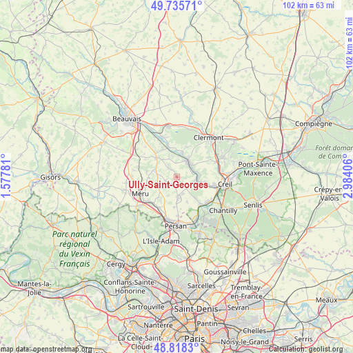
Ully-Saint-Georges GPS coordinates[2]
49° 16' 44.904" North, 2° 16' 51.384" East
| Map corner | latitude | longitude |
|---|---|---|
| Upper-left | 49.73571°, | 1.57781° |
| Center: | 49.27914°, | 2.28094° |
| Lower-right: | 48.8183°, | 2.98406° |
| Map W x H: | 102×102 km | = 63.4×63.4mi |
| max Lat: | 51.07786° ⇑14.3% North |
| Ully-Saint-Georges: | 49.27914° |
| min Lat: | ⇓85.7% South 41.3874° |
| min Long | Ully-Saint-Geor | max Long |
| -5.08615° | 2.28094° | 9.52242° |
| W 46.9%⇐ | ⇒53.1% E |
Elevation
Elevation of Ully-Saint-Georges is 70 m = 230 ft, and this is 123.7 m = 406 ft below average elevation for this country.
| Max E: |
2333 m = 7654 ft | 73.6% |
| Avg. | 193.7 m = 635 ft | |
| Ully-Saint-Georges | 70 m = 230 ft | |
Min E: |
-1 m = -3 ft | 26.4% |
See also: France elevation on elevation.city.
Geographical zone
Ully-Saint-Georges is located in North temperate zone (between Tropic of Cancer and the Arctic Circle). Distance of this North polar circle is 1921.8 km =1194.2 mi to North.| Distance of | km | miles | from Ully-Saint-Georges |
|---|---|---|---|
| North Pole | 4527.7 | 2813.4 | to North |
| Arctic Circle | 1921.8 | 1194.2 | to North |
| Tropic Cancer | 2873.4 | 1785.4 | to South |
| Equator | 5479.3 | 3404.7 | to South |


Nearby cities:
15 places around Ully-Saint-Georges: (largest is in red/bold)
• Angy
6.6 km =4.1 mi,  31°
31°
• Balagny-sur-Thérain
4.4 km =2.7 mi,  64°
64°
• Blaincourt-lès-Précy
7.1 km =4.4 mi,  135°
135°
• Bury
5.9 km =3.7 mi,  50°
50°
• Cauvigny
3.5 km =2.2 mi,  316°
316°
• Cires-lès-Mello
5.7 km =3.5 mi,  97°
97°
• Ercuis
5.2 km =3.2 mi,  161°
161°
• Heilles
6.3 km =3.9 mi,  350°
350°
• Hondainville
7 km =4.3 mi,  12°
12°
• Lachapelle-Saint-Pierre
3.5 km =2.2 mi,  251°
251°
• Mortefontaine-en-Thelle
7 km =4.3 mi,  256°
256°
• Mouy
4.9 km =3 mi, 34°
• Neuilly-en-Thelle
6.1 km =3.8 mi,  177°
177°
• Puiseux-le-Hauberger
7.6 km =4.7 mi,  204°
204°
• Sainte-Geneviève
6 km =3.7 mi,  280°
280°
Sources, notices
• [Note1] Compared only with cities in France existing in our database
• [Src1] Map data: © OpenStreetMap contributors (CC-BY-SA)
• [Src2] Other city data from geonames.org with taken over terms of usage.
• [Src3] Geographical zone / Annual Mean Temperature by Robert A. Rohde @ Wikipedia
