Moussy geodata
Moussy (Grand Est) is a populated place; located in France in Europe/Paris (GMT+2) time zone. With population of 742 people, there are 11263 cities with bigger population in this country. Compared to other cities in France, 80% of cities are located further ↓South; 67.1% of cities are located further ←West and 60.8% of cities have higher elevation than Moussy. Note1
Administrative division(s):
- Level 1: Grand Est
- Level 2: Marne
- Level 3: Arrondissement d'Épernay
- Level 4: Moussy


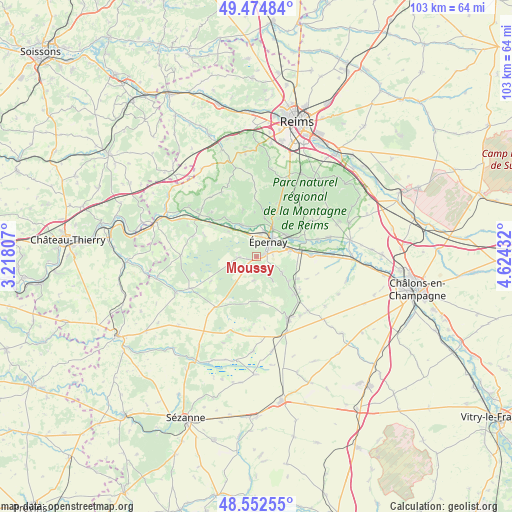
Moussy GPS coordinates[2]
49° 0' 56.988" North, 3° 55' 16.284" East
| Map corner | latitude | longitude |
|---|---|---|
| Upper-left | 49.47484°, | 3.21807° |
| Center: | 49.01583°, | 3.92119° |
| Lower-right: | 48.55255°, | 4.62432° |
| Map W x H: | 102.5×102.5 km | = 63.7×63.7mi |
| max Lat: | 51.07786° ⇑20% North |
| Moussy: | 49.01583° |
| min Lat: | ⇓80% South 41.3874° |
| min Long | Moussy | max Long |
| -5.08615° | 3.92119° | 9.52242° |
| W 67.1%⇐ | ⇒32.9% E |
Elevation
Elevation of Moussy is 100 m = 328 ft, and this is 93.7 m = 307 ft below average elevation for this country.
| Max E: |
2333 m = 7654 ft | 60.8% |
| Avg. | 193.7 m = 635 ft | |
| Moussy | 100 m = 328 ft | |
Min E: |
-1 m = -3 ft | 39.2% |
See also: France elevation on elevation.city.
Geographical zone
Moussy is located in North temperate zone (between Tropic of Cancer and the Arctic Circle). Distance of this North polar circle is 1951.1 km =1212.4 mi to North.| Distance of | km | miles | from Moussy |
|---|---|---|---|
| North Pole | 4557 | 2831.6 | to North |
| Arctic Circle | 1951.1 | 1212.4 | to North |
| Tropic Cancer | 2844.1 | 1767.2 | to South |
| Equator | 5450 | 3386.5 | to South |


Nearby cities:
15 places around Moussy: (largest is in red/bold)
• Avize
8.3 km =5.2 mi,  124°
124°
• Ay
7.4 km =4.6 mi,  54°
54°
• Boursault
7.4 km =4.6 mi,  311°
311°
• Chouilly
6.9 km =4.3 mi,  81°
81°
• Cramant
6 km =3.7 mi, 121°
• Cumières
6.3 km =3.9 mi,  4°
4°
• Damery
7 km =4.3 mi,  334°
334°
• Dizy
6.6 km =4.1 mi,  30°
30°
• Grauves
5.6 km =3.5 mi,  146°
146°
• Hautvillers
7.7 km =4.8 mi,  12°
12°
• Magenta
5.1 km =3.2 mi,  43°
43°
• Mardeuil
4.3 km =2.7 mi, 8°
• Pierry
1.5 km =0.9 mi,  70°
70°
• Vinay
1.7 km =1.1 mi,  250°
250°
• Épernay
3.9 km =2.4 mi, 45°
Sources, notices
• [Note1] Compared only with cities in France existing in our database
• [Src1] Map data: © OpenStreetMap contributors (CC-BY-SA)
• [Src2] Other city data from geonames.org with taken over terms of usage.
• [Src3] Geographical zone / Annual Mean Temperature by Robert A. Rohde @ Wikipedia
