Chorey-les-Beaune geodata
Chorey-les-Beaune (Bourgogne-Franche-Comté) is a populated place; located in France in Europe/Paris (GMT+2) time zone. With population of 532 people, there are 14567 cities with bigger population in this country. Compared to other cities in France, 54.8% of cities are located further ↑North; 76% of cities are located further ←West and 70.1% of cities have lower elevation than Chorey-les-Beaune. Note1
Administrative division(s):
- Level 1: Bourgogne-Franche-Comté
- Level 2: Département de la Côte-d'Or
- Level 3: Arrondissement de Beaune
- Level 4: Chorey-les-Beaune


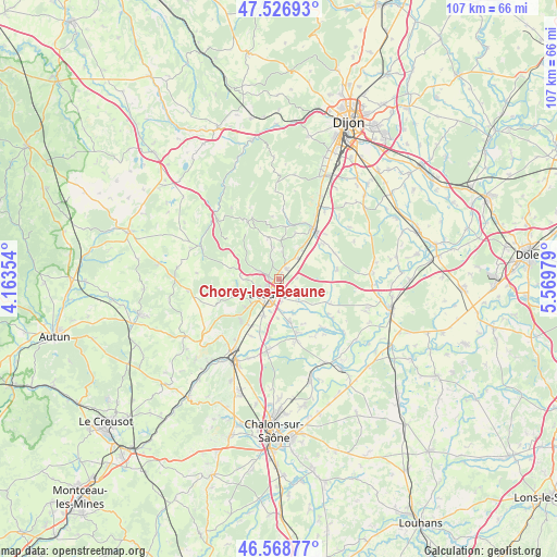
Chorey-les-Beaune GPS coordinates[2]
47° 3' 0" North, 4° 52' 0.012" East
| Map corner | latitude | longitude |
|---|---|---|
| Upper-left | 47.52693°, | 4.16354° |
| Center: | 47.05°, | 4.86667° |
| Lower-right: | 46.56877°, | 5.56979° |
| Map W x H: | 106.5×106.5 km | = 66.2×66.2mi |
| max Lat: | 51.07786° ⇑54.8% North |
| Chorey-les-Beaune: | 47.05° |
| min Lat: | ⇓45.2% South 41.3874° |
| min Long | Chorey-les-Beau | max Long |
| -5.08615° | 4.86667° | 9.52242° |
| W 76%⇐ | ⇒24% E |
Elevation
Elevation of Chorey-les-Beaune is 220 m = 722 ft, and this is 26.3 m = 86 ft above average elevation for this country.
| Max E: |
2333 m = 7654 ft | 29.9% |
| Chorey-les-Beaune | 220 m 722 ft | |
| Avg. | 193.7 m = 635 ft | |
Min E: |
-1 m = -3 ft | 70.1% |
See also: France elevation on elevation.city.
Geographical zone
Chorey-les-Beaune is located in North temperate zone (between Tropic of Cancer and the Arctic Circle). Distance of this North polar circle is 2169.7 km =1348.2 mi to North.| Distance of | km | miles | from Chorey-les-Beaune |
|---|---|---|---|
| North Pole | 4775.6 | 2967.4 | to North |
| Arctic Circle | 2169.7 | 1348.2 | to North |
| Tropic Cancer | 2625.6 | 1631.5 | to South |
| Equator | 5231.5 | 3250.7 | to South |


Nearby cities:
15 places around Chorey-les-Beaune: (largest is in red/bold)
• Beaune
3.6 km =2.2 mi,  216°
216°
• Bligny-lès-Beaune
7.7 km =4.8 mi,  203°
203°
• Comblanchien
7.1 km =4.4 mi,  35°
35°
• Corgoloin
5.2 km =3.2 mi, 42°
• Ladoix-Serrigny
2.2 km =1.4 mi,  34°
34°
• Merceuil
11.3 km =7 mi,  189°
189°
• Meursault
10.9 km =6.8 mi, 222°
• Montagny-lès-Beaune
6.6 km =4.1 mi, 191°
• Nuits-Saint-Georges
11.5 km =7.1 mi, 32°
• Pommard
7.1 km =4.4 mi,  230°
230°
• Ruffey-lès-Beaune
5 km =3.1 mi,  134°
134°
• Saint-Loup-Géanges
11.4 km =7.1 mi,  167°
167°
• Sainte-Marie-la-Blanche
8.2 km =5.1 mi, 167°
• Savigny-lès-Beaune
4 km =2.5 mi,  292°
292°
• Vignoles
2.8 km =1.7 mi,  145°
145°
Sources, notices
• [Note1] Compared only with cities in France existing in our database
• [Src1] Map data: © OpenStreetMap contributors (CC-BY-SA)
• [Src2] Other city data from geonames.org with taken over terms of usage.
• [Src3] Geographical zone / Annual Mean Temperature by Robert A. Rohde @ Wikipedia
