Nuits-Saint-Georges geodata
Nuits-Saint-Georges (Bourgogne-Franche-Comté) is a populated place; located in France in Europe/Paris (GMT+2) time zone. With population of 5,300 people, there are 1859 cities with bigger population in this country. Compared to other cities in France, 53.8% of cities are located further ↑North; 77.1% of cities are located further ←West and 74% of cities have lower elevation than Nuits-Saint-Georges. Note1
Administrative division(s):
- Level 1: Bourgogne-Franche-Comté
- Level 2: Département de la Côte-d'Or
- Level 3: Arrondissement de Beaune
- Level 4: Nuits-Saint-Georges


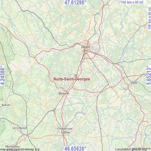
Nuits-Saint-Georges GPS coordinates[2]
47° 8' 12.588" North, 4° 56' 56.4" East
| Map corner | latitude | longitude |
|---|---|---|
| Upper-left | 47.61298°, | 4.24588° |
| Center: | 47.13683°, | 4.949° |
| Lower-right: | 46.65638°, | 5.65213° |
| Map W x H: | 106.4×106.4 km | = 66.1×66.1mi |
| max Lat: | 51.07786° ⇑53.8% North |
| Nuits-Saint-Georges: | 47.13683° |
| min Lat: | ⇓46.2% South 41.3874° |
| min Long | Nuits-Saint-Geo | max Long |
| -5.08615° | 4.949° | 9.52242° |
| W 77.1%⇐ | ⇒22.9% E |
Elevation
Elevation of Nuits-Saint-Georges is 242 m = 794 ft, and this is 48.3 m = 158 ft above average elevation for this country.
| Max E: |
2333 m = 7654 ft | 26% |
| Nuits-Saint-Georges | 242 m 794 ft | |
| Avg. | 193.7 m = 635 ft | |
Min E: |
-1 m = -3 ft | 74% |
See also: France elevation on elevation.city.
Geographical zone
Nuits-Saint-Georges is located in North temperate zone (between Tropic of Cancer and the Arctic Circle). Distance of this North polar circle is 2160 km =1342.2 mi to North.| Distance of | km | miles | from Nuits-Saint-Georges |
|---|---|---|---|
| North Pole | 4765.9 | 2961.4 | to North |
| Arctic Circle | 2160 | 1342.2 | to North |
| Tropic Cancer | 2635.2 | 1637.4 | to South |
| Equator | 5241.1 | 3256.7 | to South |


Nearby cities:
15 places around Nuits-Saint-Georges: (largest is in red/bold)
• Brochon
11.4 km =7.1 mi,  7°
7°
• Chorey-les-Beaune
11.5 km =7.1 mi,  212°
212°
• Comblanchien
4.4 km =2.7 mi, 208°
• Corcelles-lès-Cîteaux
10.7 km =6.6 mi,  68°
68°
• Corgoloin
6.4 km =4 mi, 205°
• Fixin
12.2 km =7.6 mi, 8°
• Flagey-Echézeaux
4.2 km =2.6 mi,  38°
38°
• Gevrey-Chambertin
10 km =6.2 mi, 8°
• Gilly-lès-Cîteaux
4 km =2.5 mi, 36°
• Ladoix-Serrigny
9.2 km =5.7 mi, 212°
• Morey-Saint-Denis
6.8 km =4.2 mi, 8°
• Noiron-sous-Gevrey
11.7 km =7.3 mi,  57°
57°
• Saulon-la-Rue
12.8 km =8 mi, 42°
• Savigny-lès-Beaune
12.8 km =8 mi,  230°
230°
• Vignoles
12.8 km =8 mi,  201°
201°
Sources, notices
• [Note1] Compared only with cities in France existing in our database
• [Src1] Map data: © OpenStreetMap contributors (CC-BY-SA)
• [Src2] Other city data from geonames.org with taken over terms of usage.
• [Src3] Geographical zone / Annual Mean Temperature by Robert A. Rohde @ Wikipedia
