Chézy-sur-Marne geodata
Chézy-sur-Marne (Hauts-de-France) is a populated place; located in France in Europe/Paris (GMT+2) time zone. With population of 1,361 people, there are 6759 cities with bigger population in this country. Compared to other cities in France, 79.4% of cities are located further ↓South; 62.9% of cities are located further ←West and 76.6% of cities have higher elevation than Chézy-sur-Marne. Note1
Administrative division(s):
- Level 1: Hauts-de-France
- Level 2: Département de l'Aisne
- Level 3: Arrondissement de Château-Thierry
- Level 4: Chézy-sur-Marne


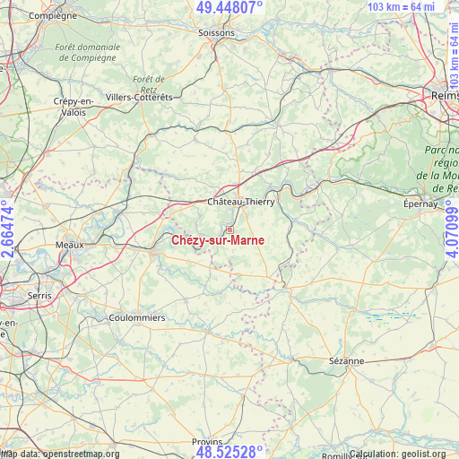
Chézy-sur-Marne GPS coordinates[2]
48° 59' 19.716" North, 3° 22' 4.296" East
| Map corner | latitude | longitude |
|---|---|---|
| Upper-left | 49.44807°, | 2.66474° |
| Center: | 48.98881°, | 3.36786° |
| Lower-right: | 48.52528°, | 4.07099° |
| Map W x H: | 102.6×102.6 km | = 63.8×63.8mi |
| max Lat: | 51.07786° ⇑20.6% North |
| Chézy-sur-Marne: | 48.98881° |
| min Lat: | ⇓79.4% South 41.3874° |
| min Long | Chézy-sur-Marn | max Long |
| -5.08615° | 3.36786° | 9.52242° |
| W 62.9%⇐ | ⇒37.1% E |
Elevation
Elevation of Chézy-sur-Marne is 63 m = 207 ft, and this is 130.7 m = 429 ft below average elevation for this country.
| Max E: |
2333 m = 7654 ft | 76.6% |
| Avg. | 193.7 m = 635 ft | |
| Chézy-sur-Marne | 63 m = 207 ft | |
Min E: |
-1 m = -3 ft | 23.4% |
See also: France elevation on elevation.city.
Geographical zone
Chézy-sur-Marne is located in North temperate zone (between Tropic of Cancer and the Arctic Circle). Distance of this North polar circle is 1954.1 km =1214.2 mi to North.| Distance of | km | miles | from Chézy-sur-Marne |
|---|---|---|---|
| North Pole | 4560 | 2833.5 | to North |
| Arctic Circle | 1954.1 | 1214.2 | to North |
| Tropic Cancer | 2841.1 | 1765.4 | to South |
| Equator | 5447 | 3384.6 | to South |


Nearby cities:
15 places around Chézy-sur-Marne: (largest is in red/bold)
• Brasles
8 km =5 mi,  34°
34°
• Charly-sur-Marne
6.2 km =3.9 mi,  258°
258°
• Chierry
7.2 km =4.5 mi,  38°
38°
• Château-Thierry
6.9 km =4.3 mi,  21°
21°
• Citry
9.6 km =6 mi, 256°
• Domptin
7.3 km =4.5 mi,  295°
295°
• Essômes-sur-Marne
4.5 km =2.8 mi,  7°
7°
• Fossoy
10.7 km =6.6 mi,  51°
51°
• Nesles-la-Montagne
5.5 km =3.4 mi, 51°
• Nogent-l’Artaud
4.2 km =2.6 mi,  232°
232°
• Nogentel
4.1 km =2.5 mi, 38°
• Pavant
7.2 km =4.5 mi,  236°
236°
• Saulchery
4.6 km =2.9 mi,  251°
251°
• Viels-Maisons
10.5 km =6.5 mi,  168°
168°
• Étampes-sur-Marne
6.3 km =3.9 mi, 36°
Sources, notices
• [Note1] Compared only with cities in France existing in our database
• [Src1] Map data: © OpenStreetMap contributors (CC-BY-SA)
• [Src2] Other city data from geonames.org with taken over terms of usage.
• [Src3] Geographical zone / Annual Mean Temperature by Robert A. Rohde @ Wikipedia
