Chevru geodata
Chevru (Île-de-France) is a populated place; located in France in Europe/Paris (GMT+2) time zone. With population of 931 people, there are 9375 cities with bigger population in this country. Compared to other cities in France, 74% of cities are located further ↓South; 60.5% of cities are located further ←West and 55% of cities have lower elevation than Chevru. Note1
Administrative division(s):
- Level 1: Île-de-France
- Level 2: Seine-et-Marne
- Level 3: Arrondissement de Meaux
- Level 4: Chevru


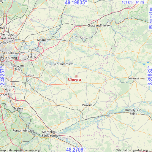
Chevru GPS coordinates[2]
48° 44' 12.336" North, 3° 11' 44.484" East
| Map corner | latitude | longitude |
|---|---|---|
| Upper-left | 49.19835°, | 2.49257° |
| Center: | 48.73676°, | 3.19569° |
| Lower-right: | 48.2709°, | 3.89882° |
| Map W x H: | 103.1×103.1 km | = 64.1×64.1mi |
| max Lat: | 51.07786° ⇑26% North |
| Chevru: | 48.73676° |
| min Lat: | ⇓74% South 41.3874° |
| min Long | Chevru | max Long |
| -5.08615° | 3.19569° | 9.52242° |
| W 60.5%⇐ | ⇒39.5% E |
Elevation
Elevation of Chevru is 150 m = 492 ft, and this is 43.7 m = 143 ft below average elevation for this country.
| Max E: |
2333 m = 7654 ft | 45% |
| Avg. | 193.7 m = 635 ft | |
| Chevru | 150 m = 492 ft | |
Min E: |
-1 m = -3 ft | 55% |
See also: France elevation on elevation.city.
Geographical zone
Chevru is located in North temperate zone (between Tropic of Cancer and the Arctic Circle). Distance of this North polar circle is 1982.2 km =1231.7 mi to North.| Distance of | km | miles | from Chevru |
|---|---|---|---|
| North Pole | 4588 | 2850.9 | to North |
| Arctic Circle | 1982.2 | 1231.7 | to North |
| Tropic Cancer | 2813.1 | 1748 | to South |
| Equator | 5419 | 3367.2 | to South |


Nearby cities:
15 places around Chevru: (largest is in red/bold)
• Amillis
4.9 km =3 mi,  275°
275°
• Bannost-Villegagnon
6.5 km =4 mi,  182°
182°
• Beautheil
8.5 km =5.3 mi,  290°
290°
• Beton-Bazoches
5.4 km =3.4 mi,  138°
138°
• Boissy-le-Châtel
10.3 km =6.4 mi,  335°
335°
• Chailly-en-Brie
7.9 km =4.9 mi,  318°
318°
• Chauffry
8.4 km =5.2 mi,  352°
352°
• Choisy-en-Brie
2.9 km =1.8 mi,  32°
32°
• Jouy-le-Châtel
9.2 km =5.7 mi,  211°
211°
• Jouy-sur-Morin
8.6 km =5.3 mi,  40°
40°
• La Ferté-Gaucher
9.6 km =6 mi,  57°
57°
• Saint-Denis-lès-Rebais
11 km =6.8 mi,  5°
5°
• Saint-Rémy-la-Vanne
6.7 km =4.2 mi,  23°
23°
• Saint-Siméon
6.9 km =4.3 mi,  4°
4°
• Vaudoy-en-Brie
10 km =6.2 mi,  237°
237°
Sources, notices
• [Note1] Compared only with cities in France existing in our database
• [Src1] Map data: © OpenStreetMap contributors (CC-BY-SA)
• [Src2] Other city data from geonames.org with taken over terms of usage.
• [Src3] Geographical zone / Annual Mean Temperature by Robert A. Rohde @ Wikipedia
