Boissy-le-Châtel geodata
Boissy-le-Châtel (Île-de-France) is a populated place; located in France in Europe/Paris (GMT+2) time zone. With population of 2,926 people, there are 3333 cities with bigger population in this country. Compared to other cities in France, 76% of cities are located further ↓South; 59.8% of cities are located further ←West and 55.2% of cities have higher elevation than Boissy-le-Châtel. Note1
Administrative division(s):
- Level 1: Île-de-France
- Level 2: Seine-et-Marne
- Level 3: Arrondissement de Meaux
- Level 4: Boissy-le-Châtel


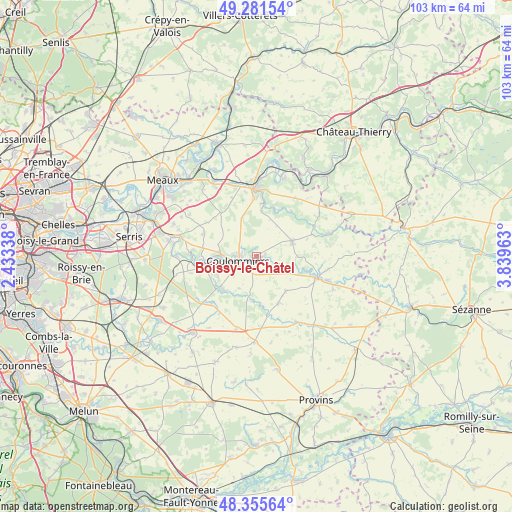
Boissy-le-Châtel GPS coordinates[2]
48° 49' 14.628" North, 3° 8' 11.436" East
| Map corner | latitude | longitude |
|---|---|---|
| Upper-left | 49.28154°, | 2.43338° |
| Center: | 48.82073°, | 3.13651° |
| Lower-right: | 48.35564°, | 3.83963° |
| Map W x H: | 103×102.9 km | = 64×63.9mi |
| max Lat: | 51.07786° ⇑24% North |
| Boissy-le-Châtel: | 48.82073° |
| min Lat: | ⇓76% South 41.3874° |
| min Long | Boissy-le-Chât | max Long |
| -5.08615° | 3.13651° | 9.52242° |
| W 59.8%⇐ | ⇒40.2% E |
Elevation
Elevation of Boissy-le-Châtel is 116 m = 381 ft, and this is 77.7 m = 255 ft below average elevation for this country.
| Max E: |
2333 m = 7654 ft | 55.2% |
| Avg. | 193.7 m = 635 ft | |
| Boissy-le-Châtel | 116 m = 381 ft | |
Min E: |
-1 m = -3 ft | 44.8% |
See also: France elevation on elevation.city.
Geographical zone
Boissy-le-Châtel is located in North temperate zone (between Tropic of Cancer and the Arctic Circle). Distance of this North polar circle is 1972.8 km =1225.8 mi to North.| Distance of | km | miles | from Boissy-le-Châtel |
|---|---|---|---|
| North Pole | 4578.7 | 2845.1 | to North |
| Arctic Circle | 1972.8 | 1225.8 | to North |
| Tropic Cancer | 2822.4 | 1753.8 | to South |
| Equator | 5428.4 | 3373.1 | to South |


Nearby cities:
15 places around Boissy-le-Châtel: (largest is in red/bold)
• Amillis
8.9 km =5.5 mi,  183°
183°
• Beautheil
7.4 km =4.6 mi,  209°
209°
• Chailly-en-Brie
3.5 km =2.2 mi,  194°
194°
• Chauffry
3.4 km =2.1 mi,  107°
107°
• Choisy-en-Brie
9.1 km =5.7 mi,  139°
139°
• Coulommiers
3.8 km =2.4 mi,  259°
259°
• Doue
5.4 km =3.4 mi,  20°
20°
• Mouroux
7.2 km =4.5 mi,  271°
271°
• Pommeuse
8.8 km =5.5 mi, 267°
• Rebais
7.6 km =4.7 mi,  67°
67°
• Saint-Augustin
8.8 km =5.5 mi,  241°
241°
• Saint-Denis-lès-Rebais
5.6 km =3.5 mi, 73°
• Saint-Rémy-la-Vanne
7.7 km =4.8 mi, 114°
• Saint-Siméon
5.5 km =3.4 mi,  116°
116°
• Saints
9.4 km =5.8 mi,  224°
224°
Sources, notices
• [Note1] Compared only with cities in France existing in our database
• [Src1] Map data: © OpenStreetMap contributors (CC-BY-SA)
• [Src2] Other city data from geonames.org with taken over terms of usage.
• [Src3] Geographical zone / Annual Mean Temperature by Robert A. Rohde @ Wikipedia
