Chevrières geodata
Chevrières (Auvergne-Rhône-Alpes) is a populated place; located in France in Europe/Paris (GMT+2) time zone. With population of 862 people, there are 9979 cities with bigger population in this country. Compared to other cities in France, 72.7% of cities are located further ↑North; 71.4% of cities are located further ←West and 96% of cities have lower elevation than Chevrières. Note1
Administrative division(s):
- Level 1: Auvergne-Rhône-Alpes
- Level 2: Département de la Loire
- Level 3: Arrondissement de Montbrison
- Level 4: Chevrières


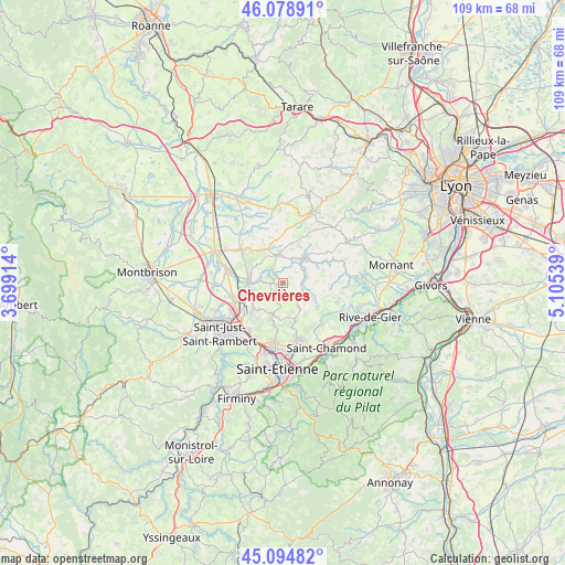
Chevrières GPS coordinates[2]
45° 35' 20.472" North, 4° 24' 8.136" East
| Map corner | latitude | longitude |
|---|---|---|
| Upper-left | 46.07891°, | 3.69914° |
| Center: | 45.58902°, | 4.40226° |
| Lower-right: | 45.09482°, | 5.10539° |
| Map W x H: | 109.4×109.4 km | = 68×68mi |
| max Lat: | 51.07786° ⇑72.7% North |
| Chevrières: | 45.58902° |
| min Lat: | ⇓27.3% South 41.3874° |
| min Long | Chevrières | max Long |
| -5.08615° | 4.40226° | 9.52242° |
| W 71.4%⇐ | ⇒28.6% E |
Elevation
Elevation of Chevrières is 643 m = 2110 ft, and this is 449.3 m = 1474 ft above average elevation for this country.
| Max E: |
2333 m = 7654 ft | 4% |
| Chevrières | 643 m 2110 ft | |
| Avg. | 193.7 m = 635 ft | |
Min E: |
-1 m = -3 ft | 96% |
See also: France elevation on elevation.city.
Geographical zone
Chevrières is located in North temperate zone (between Tropic of Cancer and the Arctic Circle). Distance of this North polar circle is 2332.2 km =1449.2 mi to North.| Distance of | km | miles | from Chevrières |
|---|---|---|---|
| North Pole | 4938 | 3068.3 | to North |
| Arctic Circle | 2332.2 | 1449.2 | to North |
| Tropic Cancer | 2463.1 | 1530.5 | to South |
| Equator | 5069 | 3149.7 | to South |


Nearby cities:
15 places around Chevrières: (largest is in red/bold)
• Aveizieux
3.6 km =2.2 mi,  222°
222°
• Chambœuf
6.7 km =4.2 mi,  264°
264°
• Chazelles-sur-Lyon
5.5 km =3.4 mi,  349°
349°
• Coise
6.2 km =3.9 mi,  63°
63°
• Fontanès
5.5 km =3.4 mi,  147°
147°
• Grammond
4 km =2.5 mi,  129°
129°
• Grézieu-le-Marché
7.6 km =4.7 mi,  11°
11°
• Marcenod
6.6 km =4.1 mi,  107°
107°
• Pomeys
7.5 km =4.7 mi,  25°
25°
• Saint-Bonnet-les-Oules
7.4 km =4.6 mi,  233°
233°
• Saint-Denis-sur-Coise
3.3 km =2.1 mi, 32°
• Saint-Galmier
7.2 km =4.5 mi,  277°
277°
• Saint-Héand
7.3 km =4.5 mi,  199°
199°
• Saint-Médard-en-Forez
3.4 km =2.1 mi,  291°
291°
• Saint-Symphorien-sur-Coise
6.4 km =4 mi,  41°
41°
Sources, notices
• [Note1] Compared only with cities in France existing in our database
• [Src1] Map data: © OpenStreetMap contributors (CC-BY-SA)
• [Src2] Other city data from geonames.org with taken over terms of usage.
• [Src3] Geographical zone / Annual Mean Temperature by Robert A. Rohde @ Wikipedia
