Marcenod geodata
Marcenod (Auvergne-Rhône-Alpes) is a populated place; located in France in Europe/Paris (GMT+2) time zone. With population of 599 people, there are 13333 cities with bigger population in this country. Compared to other cities in France, 73% of cities are located further ↑North; 72% of cities are located further ←West and 97.5% of cities have lower elevation than Marcenod. Note1
Administrative division(s):
- Level 1: Auvergne-Rhône-Alpes
- Level 2: Département de la Loire
- Level 3: Arrondissement de Saint-Étienne
- Level 4: Marcenod


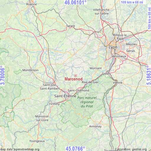
Marcenod GPS coordinates[2]
45° 34' 15.456" North, 4° 28' 59.448" East
| Map corner | latitude | longitude |
|---|---|---|
| Upper-left | 46.06101°, | 3.78006° |
| Center: | 45.57096°, | 4.48318° |
| Lower-right: | 45.0766°, | 5.18631° |
| Map W x H: | 109.5×109.5 km | = 68×68mi |
| max Lat: | 51.07786° ⇑73% North |
| Marcenod: | 45.57096° |
| min Lat: | ⇓27% South 41.3874° |
| min Long | Marcenod | max Long |
| -5.08615° | 4.48318° | 9.52242° |
| W 72%⇐ | ⇒28% E |
Elevation
Elevation of Marcenod is 768 m = 2520 ft, and this is 574.3 m = 1884 ft above average elevation for this country.
| Max E: |
2333 m = 7654 ft | 2.5% |
| Marcenod | 768 m 2520 ft | |
| Avg. | 193.7 m = 635 ft | |
Min E: |
-1 m = -3 ft | 97.5% |
See also: France elevation on elevation.city.
Geographical zone
Marcenod is located in North temperate zone (between Tropic of Cancer and the Arctic Circle). Distance of this North polar circle is 2334.2 km =1450.4 mi to North.| Distance of | km | miles | from Marcenod |
|---|---|---|---|
| North Pole | 4940 | 3069.6 | to North |
| Arctic Circle | 2334.2 | 1450.4 | to North |
| Tropic Cancer | 2461.1 | 1529.3 | to South |
| Equator | 5067 | 3148.5 | to South |


Nearby cities:
15 places around Marcenod: (largest is in red/bold)
• Aveizieux
8.8 km =5.5 mi,  265°
265°
• Cellieu
7.5 km =4.7 mi,  141°
141°
• Chevrières
6.6 km =4.1 mi,  287°
287°
• Coise
4.8 km =3 mi,  350°
350°
• Fontanès
4.2 km =2.6 mi,  231°
231°
• Grammond
3.2 km =2 mi,  260°
260°
• Larajasse
5 km =3.1 mi,  16°
16°
• Pomeys
9.3 km =5.8 mi,  340°
340°
• Saint-Christo-en-Jarez
2.9 km =1.8 mi,  172°
172°
• Saint-Denis-sur-Coise
6.6 km =4.1 mi,  316°
316°
• Saint-Martin-la-Plaine
9.3 km =5.8 mi,  107°
107°
• Saint-Romain-en-Jarez
4.3 km =2.7 mi, 108°
• Saint-Symphorien-sur-Coise
7.1 km =4.4 mi, 343°
• Sainte-Catherine
7.4 km =4.6 mi,  65°
65°
• Valfleury
5.4 km =3.4 mi, 172°
Sources, notices
• [Note1] Compared only with cities in France existing in our database
• [Src1] Map data: © OpenStreetMap contributors (CC-BY-SA)
• [Src2] Other city data from geonames.org with taken over terms of usage.
• [Src3] Geographical zone / Annual Mean Temperature by Robert A. Rohde @ Wikipedia
