Coise geodata
Coise (Auvergne-Rhône-Alpes) is a populated place; located in France in Europe/Paris (GMT+2) time zone. With population of 710 people, there are 11647 cities with bigger population in this country. Compared to other cities in France, 72.4% of cities are located further ↑North; 71.9% of cities are located further ←West and 96% of cities have lower elevation than Coise. Note1
Administrative division(s):
- Level 1: Auvergne-Rhône-Alpes
- Level 2: Département du Rhône
- Level 3: Arrondissement de Lyon
- Level 4: Coise


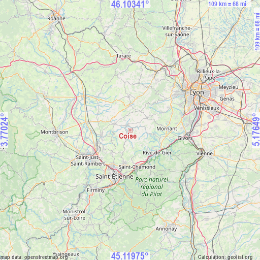
Coise GPS coordinates[2]
45° 36' 49.464" North, 4° 28' 24.096" East
| Map corner | latitude | longitude |
|---|---|---|
| Upper-left | 46.10341°, | 3.77024° |
| Center: | 45.61374°, | 4.47336° |
| Lower-right: | 45.11975°, | 5.17649° |
| Map W x H: | 109.4×109.4 km | = 68×68mi |
| max Lat: | 51.07786° ⇑72.4% North |
| Coise: | 45.61374° |
| min Lat: | ⇓27.6% South 41.3874° |
| min Long | Coise | max Long |
| -5.08615° | 4.47336° | 9.52242° |
| W 71.9%⇐ | ⇒28.1% E |
Elevation
Elevation of Coise is 648 m = 2126 ft, and this is 454.3 m = 1490 ft above average elevation for this country.
| Max E: |
2333 m = 7654 ft | 4% |
| Coise | 648 m 2126 ft | |
| Avg. | 193.7 m = 635 ft | |
Min E: |
-1 m = -3 ft | 96% |
See also: France elevation on elevation.city.
Geographical zone
Coise is located in North temperate zone (between Tropic of Cancer and the Arctic Circle). Distance of this North polar circle is 2329.4 km =1447.4 mi to North.| Distance of | km | miles | from Coise |
|---|---|---|---|
| North Pole | 4935.3 | 3066.7 | to North |
| Arctic Circle | 2329.4 | 1447.4 | to North |
| Tropic Cancer | 2465.9 | 1532.2 | to South |
| Equator | 5071.8 | 3151.5 | to South |


Nearby cities:
15 places around Coise: (largest is in red/bold)
• Aveize
7.6 km =4.7 mi,  2°
2°
• Chazelles-sur-Lyon
7.1 km =4.4 mi,  292°
292°
• Chevrières
6.2 km =3.9 mi,  243°
243°
• Fontanès
7.8 km =4.8 mi,  199°
199°
• Grammond
5.8 km =3.6 mi, 204°
• Grézieu-le-Marché
6.2 km =3.9 mi,  319°
319°
• Larajasse
2.2 km =1.4 mi,  89°
89°
• Marcenod
4.8 km =3 mi,  170°
170°
• Pomeys
4.6 km =2.9 mi,  330°
330°
• Saint-Christo-en-Jarez
7.7 km =4.8 mi, 171°
• Saint-Denis-sur-Coise
3.7 km =2.3 mi,  270°
270°
• Saint-Martin-en-Haut
8.6 km =5.3 mi,  53°
53°
• Saint-Romain-en-Jarez
7.8 km =4.8 mi,  141°
141°
• Saint-Symphorien-sur-Coise
2.4 km =1.5 mi, 328°
• Sainte-Catherine
7.7 km =4.8 mi,  102°
102°
Sources, notices
• [Note1] Compared only with cities in France existing in our database
• [Src1] Map data: © OpenStreetMap contributors (CC-BY-SA)
• [Src2] Other city data from geonames.org with taken over terms of usage.
• [Src3] Geographical zone / Annual Mean Temperature by Robert A. Rohde @ Wikipedia
